
Topografische Karte Glasgow
Interaktive Karte
Klicken Sie auf die Karte, um die Höhe anzuzeigen.
Über diese Karte
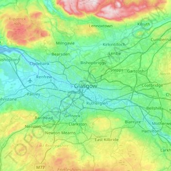
Name: Topografische Karte Glasgow, Höhe, Relief.
Ort: Glasgow, Glasgow City, Scotland, G2 1DY, United Kingdom (55.70116 -4.41017 56.02116 -4.09017)
Durchschnittliche Höhe: 128 m
Minimale Höhe: -5 m
Maximale Höhe: 554 m
Glasgow itself was reputed to have been founded by the Christian missionary Saint Mungo in the 6th century. He established a church on the Molendinar Burn, where the present Glasgow Cathedral stands, and in the following years Glasgow became a religious centre. Glasgow grew over the following centuries. The Glasgow Fair reportedly began in 1190. The first bridge over the River Clyde at Glasgow was recorded from around 1285, giving its name to the Briggait area of the city, forming the main north–south route over the river via Glasgow Cross. The founding of the University of Glasgow in 1451 and elevation of the bishopric to become the Archdiocese of Glasgow in 1492 increased the town's religious and educational status and landed wealth. Its early trade was in agriculture, brewing and fishing, with cured salmon and herring being exported to Europe and the Mediterranean.
Andere topografische Karten
Klicken Sie auf eine Karte, um ihre Topografie, ihre Höhe und ihr Relief anzuzeigen.
White Cart Water
United Kingdom > Scotland > Glasgow City > Glasgow
White Cart Water, Glasgow, Glasgow City, Scotland, United Kingdom
Durchschnittliche Höhe: 125 m
Kelvingrove Park
United Kingdom > Scotland > Glasgow City > Glasgow
Kelvingrove Park, Kelvingrove, Glasgow, Glasgow City, Scotland, United Kingdom
Durchschnittliche Höhe: 25 m
Carmunnock
United Kingdom > Scotland > Glasgow City > Carmunnock
Carmunnock, Glasgow City, Scotland, G76 9BX, United Kingdom
Durchschnittliche Höhe: 120 m