
Topografische Karte Choue
Interaktive Karte
Klicken Sie auf die Karte, um die Höhe anzuzeigen.
Über diese Karte
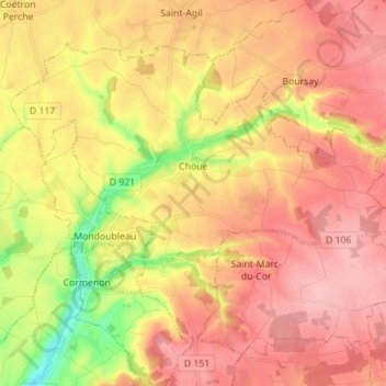
Name: Topografische Karte Choue, Höhe, Relief.
Durchschnittliche Höhe: 171 m
Minimale Höhe: 95 m
Maximale Höhe: 218 m
L'altitude du territoire communal varie de 112 mètres à 212 mètres.
Andere topografische Karten
Klicken Sie auf eine Karte, um ihre Topografie, ihre Höhe und ihr Relief anzuzeigen.
Épuisay
France > Centre-Val de Loire > Loir-et-Cher
Épuisay, Vendôme, Loir-et-Cher, Centre-Val de Loire, France métropolitaine, 41360, France
Durchschnittliche Höhe: 158 m
Les Roches-l'Évêque
France > Centre-Val de Loire > Loir-et-Cher
Les Roches-l'Évêque, Vendôme, Loir-et-Cher, Centre-Val de Loire, France métropolitaine, 41800, France
Durchschnittliche Höhe: 101 m
Montrieux-en-Sologne
France > Centre-Val de Loire > Loir-et-Cher
Montrieux-en-Sologne, Romorantin-Lanthenay, Loir-et-Cher, Centre-Val de Loire, France métropolitaine, 41210, France
Durchschnittliche Höhe: 102 m
Blanche Fontaine
France > Centre-Val de Loire > Loir-et-Cher > Prunay-Cassereau
Blanche Fontaine, Prunay-Cassereau, Vendôme, Loir-et-Cher, Centre-Val de Loire, France métropolitaine, 41310, France
Durchschnittliche Höhe: 130 m
Onzain
France > Centre-Val de Loire > Loir-et-Cher > Veuzain-sur-Loire
Onzain, Veuzain-sur-Loire, Blois, Loir-et-Cher, Centre-Val de Loire, France métropolitaine, 41150, France
Durchschnittliche Höhe: 91 m
Authon
France > Centre-Val de Loire > Loir-et-Cher
Authon, Vendôme, Loir-et-Cher, Centre-Val de Loire, France métropolitaine, 41310, France
Durchschnittliche Höhe: 133 m
Gros Chêne
France > Centre-Val de Loire > Loir-et-Cher > Busloup
Gros Chêne, Busloup, Vendôme, Loir-et-Cher, Centre-Val de Loire, France métropolitaine, 41160, France
Durchschnittliche Höhe: 137 m
Fresnes
France > Centre-Val de Loire > Loir-et-Cher > Fresnes
Fresnes, Romorantin-Lanthenay, Loir-et-Cher, Centre-Val de Loire, France métropolitaine, 41700, France
Durchschnittliche Höhe: 101 m
Choussy
France > Centre-Val de Loire > Loir-et-Cher > Choussy
Choussy, Romorantin-Lanthenay, Loir-et-Cher, Centre-Val de Loire, France métropolitaine, 41700, France
Durchschnittliche Höhe: 106 m
Houssay
France > Centre-Val de Loire > Loir-et-Cher > Houssay
Houssay, Vendôme, Loir-et-Cher, Centre-Val de Loire, France métropolitaine, 41800, France
Durchschnittliche Höhe: 114 m
Blois
France > Centre-Val de Loire > Loir-et-Cher
Blois, Loir-et-Cher, Centre-Val de Loire, France métropolitaine, 41000, France
Durchschnittliche Höhe: 95 m
Cheverny
France > Centre-Val de Loire > Loir-et-Cher > Cheverny
Cheverny, Blois, Loir-et-Cher, Centre-Val de Loire, France métropolitaine, 41700, France
Durchschnittliche Höhe: 99 m