
Topografische Karte Refugio de Vida Silvestre Los Pantanos de Villa
Interaktive Karte
Klicken Sie auf die Karte, um die Höhe anzuzeigen.
Über diese Karte
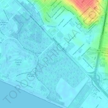
Name: Topografische Karte Refugio de Vida Silvestre Los Pantanos de Villa, Höhe, Relief.
Durchschnittliche Höhe: 10 m
Minimale Höhe: -1 m
Maximale Höhe: 67 m
Andere topografische Karten
Klicken Sie auf eine Karte, um ihre Topografie, ihre Höhe und ihr Relief anzuzeigen.
Morro Solar
Perú > Lima > Chorrillos
Morro Solar, Chorrillos, Lima, Lima Metropolitana, Lima, 15064, Perú
Durchschnittliche Höhe: 38 m
Mirador del Salto del Fraile
Perú > Lima > Chorrillos
Mirador del Salto del Fraile, Paseo Bilinghurst, Chorrillos, Lima, Lima Metropolitana, Lima, 15042, Perú
Durchschnittliche Höhe: 31 m
Refugio de Vida Silvestre Los Pantanos de Villa
Perú > Lima > Chorrillos
Refugio de Vida Silvestre Los Pantanos de Villa, Chorrillos, Lima, Lima Metropolitana, Lima, Perú
Durchschnittliche Höhe: 11 m
Playa La Chira
Perú > Lima > Chorrillos
Playa La Chira, Chorrillos, Provincia de Lima, Lima, Perú
Durchschnittliche Höhe: 7 m
Huaca La Lechuza
Perú > Lima > Chorrillos
Huaca La Lechuza, Avenida Héroes del Pacífico, Chorrillos, Provincia de Lima, Lima, LIMA 09, Perú
Durchschnittliche Höhe: 66 m
Parque Manuel Cuadros
Perú > Lima > Chorrillos
Parque Manuel Cuadros, Chorrillos, Provincia de Lima, Lima, Perú
Durchschnittliche Höhe: 35 m
Playa Villa
Perú > Lima > Chorrillos
Playa Villa, Avenida Costanera, La Encantada de Villa, Chorrillos, Lima, LIMA 09, Perú
Durchschnittliche Höhe: 4 m