
Topografische Karte Fremont
Interaktive Karte
Klicken Sie auf die Karte, um die Höhe anzuzeigen.
Über diese Karte
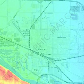
Name: Topografische Karte Fremont, Höhe, Relief.
Ort: Fremont, Dodge County, Nebraska, 68025, United States (41.41630 -96.54123 41.46409 -96.44426)
Durchschnittliche Höhe: 365 m
Minimale Höhe: 355 m
Maximale Höhe: 414 m
According to the United States Census Bureau, the city has a total area of 8.85 square miles (22.92 km2), of which 8.80 square miles (22.79 km2) is land and 0.05 square miles (0.13 km2) is water. Fremont lies in the river plain between the Platte and Elkhorn rivers, at an elevation of approximately 366 meters (1,203 ft) above sea level.
Andere topografische Karten
Klicken Sie auf eine Karte, um ihre Topografie, ihre Höhe und ihr Relief anzuzeigen.
North Bend
United States > Nebraska > Dodge County
North Bend, Dodge County, Nebraska, United States
Durchschnittliche Höhe: 388 m
Hooper
United States > Nebraska > Dodge County
Hooper, Dodge County, Nebraska, United States
Durchschnittliche Höhe: 381 m
Winslow
United States > Nebraska > Dodge County
Winslow, Dodge County, Nebraska, 68072, United States
Durchschnittliche Höhe: 374 m