
Topografische Karte Saipan
Interaktive Karte
Klicken Sie auf die Karte, um die Höhe anzuzeigen.
Über diese Karte
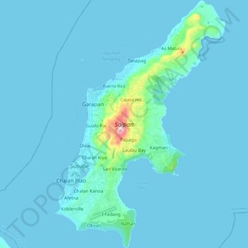
Name: Topografische Karte Saipan, Höhe, Relief.
Durchschnittliche Höhe: 22 m
Minimale Höhe: 0 m
Maximale Höhe: 462 m
The highest elevation on Saipan is a limestone-covered mountain called Mount Tapochau at 1,560 ft (480 m). Unlike many of the mountains in the Mariana Islands, it is not an extinct volcano but is a limestone formation.