
Topografische Karte Neuschottland
Interaktive Karte
Klicken Sie auf die Karte, um die Höhe anzuzeigen.
Über diese Karte
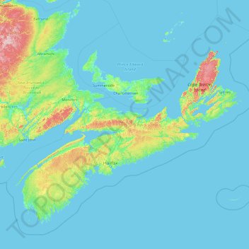
Name: Topografische Karte Neuschottland, Höhe, Relief.
Ort: Neuschottland, Kanada (43.18816 -66.68072 47.76107 -59.28871)
Durchschnittliche Höhe: 41 m
Minimale Höhe: -3 m
Maximale Höhe: 746 m
Andere topografische Karten
Klicken Sie auf eine Karte, um ihre Topografie, ihre Höhe und ihr Relief anzuzeigen.
Louiseville
Kanada > Québec > Maskinongé (MRC)
Louiseville, Maskinongé (MRC), Mauricie, Quebec, Kanada
Durchschnittliche Höhe: 17 m
Hope Island
Kanada > Britisch-Kolumbien > Regional District of Mount Waddington > Area B (Quatsino Sound/Cape Scott)
Hope Island, Area B (Quatsino Sound/Cape Scott), Regional District of Mount Waddington, Britisch-Kolumbien, Kanada
Durchschnittliche Höhe: 16 m
City of Saint John
Kanada > Neubraunschweig > Saint John County
City of Saint John, Saint John County, Neubraunschweig, Kanada
Durchschnittliche Höhe: 38 m
Latchford
Kanada > Ontario > Timiskaming District
Latchford, Timiskaming District, Northeastern Ontario, Ontario, P0J 1N0, Kanada
Durchschnittliche Höhe: 346 m
Goatfell
Kanada > Britisch-Kolumbien > Regional District of Central Kootenay > Area B (Goat River Valley)
Goatfell, Area B (Goat River Valley), Regional District of Central Kootenay, Britisch-Kolumbien, Kanada
Durchschnittliche Höhe: 975 m
Edmonton
Kanada > Alberta > Division No. 11
Edmonton, Division No. 11, Alberta, Kanada
Durchschnittliche Höhe: 690 m
Sept-Îles
Kanada > Québec > Sept-Rivières
Sept-Îles, Sept-Rivières, Côte-Nord, Quebec, Kanada
Durchschnittliche Höhe: 189 m
St. Georges Channel
Kanada > Neuschottland > Municipality of the County of Richmond
St. Georges Channel, Municipality of the County of Richmond, Richmond County, Neuschottland, B0E 3K0, Kanada
Durchschnittliche Höhe: 60 m
Cleveland
Kanada > Neuschottland > Municipality of the County of Richmond
Cleveland, Municipality of the County of Richmond, Richmond County, Neuschottland, Kanada
Durchschnittliche Höhe: 40 m
Petit Étang
Kanada > Neuschottland > Municipality of the County of Inverness
Petit Étang, Municipality of the County of Inverness, Inverness County, Neuschottland, Kanada
Durchschnittliche Höhe: 17 m
Gwich'in Settlement Area
Gwich'in Settlement Area, Nordwest-Territorien, Kanada
Durchschnittliche Höhe: 534 m
Area B (Finlay Valley/Beatton Valley)
Kanada > Britisch-Kolumbien > Peace River Regional District > Area B (Finlay Valley/Beatton Valley)
Area B (Finlay Valley/Beatton Valley), Peace River Regional District, Britisch-Kolumbien, Kanada
Durchschnittliche Höhe: 1.098 m
Area A (Kicking Horse/Kinbasket Lake)
Kanada > Britisch-Kolumbien > Columbia-Shuswap Regional District > Area A (Kicking Horse/Kinbasket Lake)
Area A (Kicking Horse/Kinbasket Lake), Columbia-Shuswap Regional District, Britisch-Kolumbien, Kanada
Durchschnittliche Höhe: 1.846 m
Area D (Kiskatinaw Valley)
Kanada > Britisch-Kolumbien > Peace River Regional District > Area D (Kiskatinaw Valley)
Area D (Kiskatinaw Valley), Peace River Regional District, Britisch-Kolumbien, Kanada
Durchschnittliche Höhe: 1.024 m
Improvement District No. 9
Kanada > Alberta > Improvement District No. 9
Improvement District No. 9, Alberta, Kanada
Durchschnittliche Höhe: 1.848 m
Kap-Breton-Insel
Kap-Breton-Insel, Neuschottland, Kanada
Durchschnittliche Höhe: 66 m
Langford
Kanada > Britisch-Kolumbien > Capital Regional District > Langford
Langford, Capital Regional District, Britisch-Kolumbien, Kanada
Durchschnittliche Höhe: 116 m
Vancouver Island
Kanada > Britisch-Kolumbien > Area D (Oyster Bay/Buttle Lake)
Vancouver Island, Britisch-Kolumbien, Kanada
Durchschnittliche Höhe: 411 m
Kitimat
Kanada > Britisch-Kolumbien > Kitimat
Kitimat, Regional District of Kitimat-Stikine, Britisch-Kolumbien, Kanada
Durchschnittliche Höhe: 445 m
Bowmanville
Kanada > Ontario > Bowmanville
Bowmanville, Durham Region, Golden Horseshoe, Ontario, L1C 1N2, Kanada
Durchschnittliche Höhe: 112 m
Red Rock River
Kanada > Ontario > Unorganized North Algoma
Red Rock River, Unorganized North Algoma, Algoma District, Ontario, Kanada
Durchschnittliche Höhe: 395 m
Sunshine Coast Regional District
Sunshine Coast Regional District, Britisch-Kolumbien, Kanada
Durchschnittliche Höhe: 699 m
Regional District of Fraser-Fort George
Regional District of Fraser-Fort George, Britisch-Kolumbien, Kanada
Durchschnittliche Höhe: 1.153 m
Saint John
Kanada > Neubraunschweig > Saint John
Saint John, City of Saint John, Saint John County, Neubraunschweig, E2L 3L6, Kanada
Durchschnittliche Höhe: 44 m
Saint Patrick Parish
Saint Patrick Parish, Charlotte County, Neubraunschweig, Kanada
Durchschnittliche Höhe: 54 m
Témiscamingue
Témiscamingue, Abitibi-Témiscamingue, Québec, Kanada
Durchschnittliche Höhe: 322 m
Sunshine Coast
Sunshine Coast, Britisch-Kolumbien, Kanada
Durchschnittliche Höhe: 649 m
La Haute-Côte-Nord
La Haute-Côte-Nord, Côte-Nord, Québec, Kanada
Durchschnittliche Höhe: 387 m
Peace River
Peace River, Britisch-Kolumbien, Kanada
Durchschnittliche Höhe: 1.118 m
Cariboo Regional District
Cariboo Regional District, Britisch-Kolumbien, Kanada
Durchschnittliche Höhe: 1.224 m
Linwood
Kanada > Neuschottland > Linwood
Linwood, Municipality of the County of Antigonish, Antigonish County, Neuschottland, Kanada
Durchschnittliche Höhe: 29 m
Mississauga
Kanada > Ontario > Mississauga
Mississauga, Peel Region, Golden Horseshoe, Ontario, Kanada
Durchschnittliche Höhe: 152 m