
Topografische Karte Traverse City
Interaktive Karte
Klicken Sie auf die Karte, um die Höhe anzuzeigen.
Über diese Karte
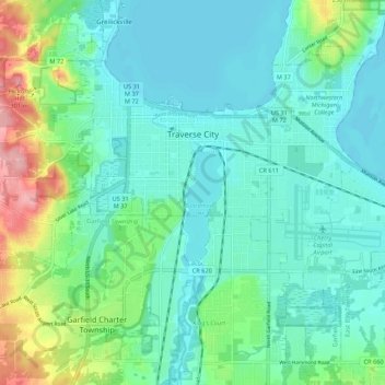
Name: Topografische Karte Traverse City, Höhe, Relief.
Durchschnittliche Höhe: 204 m
Minimale Höhe: 174 m
Maximale Höhe: 307 m
The locale and topography is conducive for road bicycling, aided by the TART trail system. A map with routes, different trips, advice and local knowledge is available. Lake Michigan presents a location for sailing, fishing, and kayaking.
Andere topografische Karten
Klicken Sie auf eine Karte, um ihre Topografie, ihre Höhe und ihr Relief anzuzeigen.
Grand Traverse Bay
United States > Michigan > Grand Traverse County
Grand Traverse Bay, Grand Traverse County, Michigan, 49682, United States
Durchschnittliche Höhe: 201 m
Interlochen
United States > Michigan > Grand Traverse County
Interlochen, Green Lake Township, Grand Traverse County, Michigan, 49643, United States
Durchschnittliche Höhe: 257 m
Williamsburg
United States > Michigan > Grand Traverse County
Williamsburg, Whitewater Township, Grand Traverse County, Michigan, 49690, United States
Durchschnittliche Höhe: 228 m
East Bay Township
United States > Michigan > Grand Traverse County
East Bay Township, Grand Traverse County, Michigan, United States
Durchschnittliche Höhe: 252 m