
Topografische Karte Cagayancillo
Interaktive Karte
Klicken Sie auf die Karte, um die Höhe anzuzeigen.
Über diese Karte
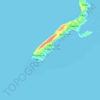
Name: Topografische Karte Cagayancillo, Höhe, Relief.
Ort: Cagayancillo, Palawan, Mimaropa, 5321, Philippines (9.53691 121.15715 9.61691 121.23715)
Durchschnittliche Höhe: 2 m
Minimale Höhe: 0 m
Maximale Höhe: 61 m
There are neither mountain ranges nor forested areas in the municipality. A hilly portion in the north-eastern part of the main island has a slope of 3-82%. The other areas are flat with the highest elevation around 2 to 3 meters. The majority of the island has a sandy loam soil not enough to support a forest.
Andere topografische Karten
Klicken Sie auf eine Karte, um ihre Topografie, ihre Höhe und ihr Relief anzuzeigen.
Cagayancillo
Philippines > Palawan > Cagayancillo
Cagayancillo, Palawan, Mimaropa, 5321, Philippines
Durchschnittliche Höhe: 0 m