
Topografische Karte Monteagle
Interaktive Karte
Klicken Sie auf die Karte, um die Höhe anzuzeigen.
Über diese Karte
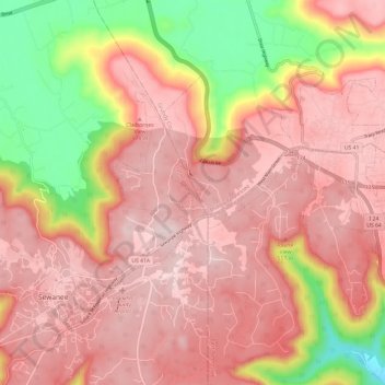
Name: Topografische Karte Monteagle, Höhe, Relief.
Ort: Monteagle, Franklin County, Tennessee, 37356, United States (35.19690 -85.90270 35.26214 -85.78295)
Durchschnittliche Höhe: 487 m
Minimale Höhe: 232 m
Maximale Höhe: 621 m
The town straddles a narrow stretch of the Cumberland Plateau known colloquially as "Monteagle Mountain".[15] This stretch of the plateau is approximately 2 miles (3 km) wide, with steep drop-offs to the northwest and southeast. Monteagle lies at an elevation of just under 2,000 feet (610 m) above sea level.[5] By comparison, two nearby cities, Cowan (to the northwest) and South Pittsburg (to the southeast), lie at elevations of less than 1,000 feet (300 m) above sea level.[16][17]
Andere topografische Karten
Klicken Sie auf eine Karte, um ihre Topografie, ihre Höhe und ihr Relief anzuzeigen.
Saint Andrews
United States > Tennessee > Franklin County > Sewanee
Saint Andrews, Sewanee, Franklin County, Middle Tennessee, Tennessee, 37383, United States
Durchschnittliche Höhe: 566 m
Winchester
United States > Tennessee > Franklin County
Winchester, Franklin County, Tennessee, United States
Durchschnittliche Höhe: 293 m