
Topografische Karte Parma
Interaktive Karte
Klicken Sie auf die Karte, um die Höhe anzuzeigen.
Über diese Karte
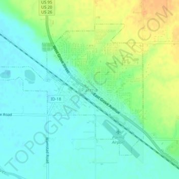
Name: Topografische Karte Parma, Höhe, Relief.
Ort: Parma, Canyon County, Idaho, 83660, United States (43.77532 -116.96597 43.79511 -116.93198)
Durchschnittliche Höhe: 686 m
Minimale Höhe: 673 m
Maximale Höhe: 708 m
Parma is located at 43°47′10″N 116°56′34″W / 43.78611°N 116.94278°W / 43.78611; -116.94278 (43.786009, -116.942656), at an elevation of 2,231 feet (680 m) above sea level.
Andere topografische Karten
Klicken Sie auf eine Karte, um ihre Topografie, ihre Höhe und ihr Relief anzuzeigen.
Nampa
United States > Idaho > Canyon County
Nampa, Canyon County, Idaho, United States
Durchschnittliche Höhe: 764 m
Caldwell
United States > Idaho > Canyon County
Caldwell, Canyon County, Idaho, United States
Durchschnittliche Höhe: 742 m
Middleton
United States > Idaho > Canyon County
Middleton, Canyon County, Idaho, 83644, United States
Durchschnittliche Höhe: 741 m
Nampa
United States > Idaho > Canyon County > Nampa
Nampa, Canyon County, Idaho, 83686, United States
Durchschnittliche Höhe: 783 m
Melba
United States > Idaho > Canyon County
Melba, Canyon County, Idaho, United States
Durchschnittliche Höhe: 798 m
Notus
United States > Idaho > Canyon County
Notus, Canyon County, Idaho, 83656, United States
Durchschnittliche Höhe: 708 m