
Topografische Karte Halawa
Interaktive Karte
Klicken Sie auf die Karte, um die Höhe anzuzeigen.
Über diese Karte
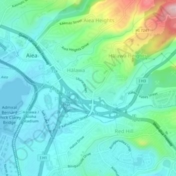
Name: Topografische Karte Halawa, Höhe, Relief.
Durchschnittliche Höhe: 79 m
Minimale Höhe: -1 m
Maximale Höhe: 307 m
The route of H-3 extends from its western terminus with east–west Moanalua Freeway (H-201; connecting eastward to Honolulu or westward to H-1 and Aiea) to the 1100-foot (335-m) elevation entrance into the Tetsuo Harano Tunnels, penetrating the Ko‘olau crest. The freeway continues beyond to Kaneohe on windward Oahu.
Andere topografische Karten
Klicken Sie auf eine Karte, um ihre Topografie, ihre Höhe und ihr Relief anzuzeigen.
Hickam Housing
United States > Hawaii > Honolulu County > Waipahu
Hickam Housing, Hickam, Aiea, Honolulu County, Hawaii, United States
Durchschnittliche Höhe: 5 m
Joint Base Pearl Harbor-Hickam
United States > Hawaii > Honolulu County > Waipahu
Joint Base Pearl Harbor-Hickam, Waipahu, Honolulu County, Hawaii, 96853, United States
Durchschnittliche Höhe: 7 m
USS Utah
United States > Hawaii > Honolulu County > Waipahu
USS Utah, Waipahu, Honolulu County, Hawaii, United States
Durchschnittliche Höhe: 2 m