
Topografische Karte Marysville
Interaktive Karte
Klicken Sie auf die Karte, um die Höhe anzuzeigen.
Über diese Karte
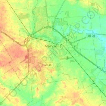
Name: Topografische Karte Marysville, Höhe, Relief.
Ort: Marysville, Union County, Ohio, United States (40.18572 -83.41420 40.27397 -83.28363)
Durchschnittliche Höhe: 308 m
Minimale Höhe: 289 m
Maximale Höhe: 328 m
Andere topografische Karten
Klicken Sie auf eine Karte, um ihre Topografie, ihre Höhe und ihr Relief anzuzeigen.
New California
United States > Ohio > Union County
New California, Jerome Township, Union County, Ohio, United States
Durchschnittliche Höhe: 299 m
Raymond
United States > Ohio > Union County
Raymond, Liberty Township, Union County, Ohio, 43067, United States
Durchschnittliche Höhe: 324 m
Byhalia
United States > Ohio > Union County
Byhalia, Washington Township, Union County, Ohio, United States
Durchschnittliche Höhe: 314 m
Broadway
United States > Ohio > Union County
Broadway, Taylor Township, Union County, Ohio, 43007, United States
Durchschnittliche Höhe: 314 m
Richwood
United States > Ohio > Union County
Richwood, Claibourne Township, Union County, Ohio, United States
Durchschnittliche Höhe: 288 m
Fleetwood Park
United States > Ohio > Union County > Marysville
Fleetwood Park, Marysville, Union County, Ohio, 43040, United States
Durchschnittliche Höhe: 304 m
Milford Center
United States > Ohio > Union County
Milford Center, Union Township, Union County, Ohio, United States
Durchschnittliche Höhe: 306 m