
Topografische Karte Pinnacles National Park
Interaktive Karte
Klicken Sie auf die Karte, um die Höhe anzuzeigen.
Über diese Karte
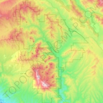
Name: Topografische Karte Pinnacles National Park, Höhe, Relief.
Durchschnittliche Höhe: 495 m
Minimale Höhe: 110 m
Maximale Höhe: 1.003 m
Elevation within the boundaries range from 824 to 3,304 feet (251 to 1,007 m) at the peak of North Chalone Peak.
Andere topografische Karten
Klicken Sie auf eine Karte, um ihre Topografie, ihre Höhe und ihr Relief anzuzeigen.
Llanada
United States > California > San Benito County
Llanada, San Benito County, California, United States
Durchschnittliche Höhe: 490 m
Paicines
United States > California > San Benito County
Paicines, San Benito County, California, United States
Durchschnittliche Höhe: 237 m
Hollister
United States > California > San Benito County
Hollister, San Benito County, California, 95023, United States
Durchschnittliche Höhe: 92 m
Laguna Mountain
United States > California > San Benito County
Laguna Mountain, San Benito County, California, United States
Durchschnittliche Höhe: 1.131 m
San Juan Bautista
United States > California > San Benito County
San Juan Bautista, San Benito County, California, 95045, United States
Durchschnittliche Höhe: 72 m
Fremont Peak State Park
United States > California > San Benito County
Fremont Peak State Park, San Benito County, California, United States
Durchschnittliche Höhe: 705 m
High Peaks
United States > California > San Benito County
High Peaks, San Benito County, California, United States
Durchschnittliche Höhe: 565 m