
Topografische Karte Prescott Valley
Interaktive Karte
Klicken Sie auf die Karte, um die Höhe anzuzeigen.
Über diese Karte
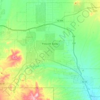
Name: Topografische Karte Prescott Valley, Höhe, Relief.
Ort: Prescott Valley, Yavapai County, Arizona, United States (34.52784 -112.38624 34.67262 -112.20168)
Durchschnittliche Höhe: 1.550 m
Minimale Höhe: 1.378 m
Maximale Höhe: 1.972 m
Prescott Valley (locally, PV) is located in central Arizona approximately 85 miles (137 km) north of Phoenix at 5,100 feet (1,600 m). elevation. PV has good access to Arizona State Route 89, SR-89A and SR-69, connecting to Interstates 17 and 40. Air service is available at Ernest A. Love Field, approximately 8 miles (13 km) northwest.
Andere topografische Karten
Klicken Sie auf eine Karte, um ihre Topografie, ihre Höhe und ihr Relief anzuzeigen.
Camp Verde
United States > Arizona > Yavapai County
Camp Verde, Yavapai County, Arizona, 86322, United States
Durchschnittliche Höhe: 1.095 m
Skull Valley
United States > Arizona > Yavapai County
Skull Valley, Yavapai County, Arizona, 86338, United States
Durchschnittliche Höhe: 1.342 m
Peeples Valley
United States > Arizona > Yavapai County
Peeples Valley, Yavapai County, Arizona, 86332, United States
Durchschnittliche Höhe: 1.472 m
Lake Montezuma
United States > Arizona > Yavapai County > Rimrock
Lake Montezuma, Rimrock, Yavapai County, Arizona, United States
Durchschnittliche Höhe: 1.075 m
Sedona
United States > Arizona > Yavapai County
Sedona, Yavapai County, Arizona, 86336, United States
Durchschnittliche Höhe: 1.342 m
Verde Village
United States > Arizona > Yavapai County
Verde Village, Yavapai County, Arizona, United States
Durchschnittliche Höhe: 1.040 m
Prescott
United States > Arizona > Yavapai County
Prescott, Yavapai County, Arizona, United States
Durchschnittliche Höhe: 1.674 m
Yarnell
United States > Arizona > Yavapai County
Yarnell, Yavapai County, Arizona, 85362, United States
Durchschnittliche Höhe: 1.472 m
Seligman
United States > Arizona > Yavapai County > Seligman
Seligman, Yavapai County, Arizona, 86337, United States
Durchschnittliche Höhe: 1.617 m
Perkinsville
United States > Arizona > Yavapai County
Perkinsville, Yavapai County, Arizona, United States
Durchschnittliche Höhe: 1.256 m
Chimney Rock
United States > Arizona > Yavapai County
Chimney Rock, Yavapai County, Arizona, 86336, United States
Durchschnittliche Höhe: 1.441 m
Kirkland
United States > Arizona > Yavapai County
Kirkland, Yavapai County, Arizona, United States
Durchschnittliche Höhe: 1.228 m
Black Canyon City
United States > Arizona > Yavapai County
Black Canyon City, Yavapai County, Arizona, 85324, United States
Durchschnittliche Höhe: 645 m
Williamson Valley Wash
United States > Arizona > Yavapai County
Williamson Valley Wash, Yavapai County, Arizona, United States
Durchschnittliche Höhe: 1.337 m
Paradise Acres
United States > Arizona > Yavapai County > Camp Verde
Paradise Acres, Camp Verde, Yavapai County, Arizona, United States
Durchschnittliche Höhe: 948 m
Mount Union Family Picnic Ground
United States > Arizona > Yavapai County
Mount Union Family Picnic Ground, Yavapai County, Arizona, United States
Durchschnittliche Höhe: 2.232 m
Arcosanti
United States > Arizona > Yavapai County
Arcosanti, Yavapai County, Arizona, United States
Durchschnittliche Höhe: 1.130 m
Clarkdale
United States > Arizona > Yavapai County
Clarkdale, Yavapai County, Arizona, 86324, United States
Durchschnittliche Höhe: 1.211 m
Dewey-Humboldt
United States > Arizona > Yavapai County
Dewey-Humboldt, Yavapai County, Arizona, 86329, United States
Durchschnittliche Höhe: 1.464 m
Lake Pleasant
United States > Arizona > Yavapai County > Peoria
Lake Pleasant, Peoria, Yavapai County, Arizona, United States
Durchschnittliche Höhe: 565 m
Mesa Verde Estates
United States > Arizona > Yavapai County > Camp Verde
Mesa Verde Estates, Camp Verde, Yavapai County, Arizona, 86322, United States
Durchschnittliche Höhe: 969 m
Jacks Canyon
United States > Arizona > Yavapai County
Jacks Canyon, Yavapai County, Arizona, United States
Durchschnittliche Höhe: 1.507 m
Ocotillo
United States > Arizona > Yavapai County
Ocotillo, Yavapai County, Arizona, United States
Durchschnittliche Höhe: 1.302 m
Paulden
United States > Arizona > Yavapai County
Paulden, Yavapai County, Arizona, United States
Durchschnittliche Höhe: 1.408 m
Blue Rock Dam
United States > Arizona > Yavapai County
Blue Rock Dam, Yavapai County, Arizona, United States
Durchschnittliche Höhe: 1.563 m
Rimrock
United States > Arizona > Yavapai County
Rimrock, Yavapai County, Arizona, 86342, United States
Durchschnittliche Höhe: 1.092 m
Cedar Bench Wilderness
United States > Arizona > Yavapai County
Cedar Bench Wilderness, Yavapai County, Arizona, United States
Durchschnittliche Höhe: 1.349 m
Clear Creek
United States > Arizona > Yavapai County > Camp Verde
Clear Creek, Camp Verde, Yavapai County, Arizona, United States
Durchschnittliche Höhe: 954 m
Miller Valley
United States > Arizona > Yavapai County > Prescott
Miller Valley, Prescott, Yavapai County, Arizona, 86305, United States
Durchschnittliche Höhe: 1.663 m
Granite Mountain Wilderness
United States > Arizona > Yavapai County
Granite Mountain Wilderness, Yavapai County, Arizona, United States
Durchschnittliche Höhe: 1.718 m
Mayer
United States > Arizona > Yavapai County
Mayer, Yavapai County, Arizona, United States
Durchschnittliche Höhe: 1.427 m
Seligman
United States > Arizona > Yavapai County
Seligman, Yavapai County, Arizona, 86337, United States
Durchschnittliche Höhe: 1.617 m
Ruin Point Tank
United States > Arizona > Yavapai County
Ruin Point Tank, Yavapai County, Arizona, United States
Durchschnittliche Höhe: 939 m
Granite Mountain
United States > Arizona > Yavapai County
Granite Mountain, Yavapai County, Arizona, United States
Durchschnittliche Höhe: 1.915 m
Willow Spring
United States > Arizona > Yavapai County
Willow Spring, Yavapai County, Arizona, United States
Durchschnittliche Höhe: 1.447 m
Chino Valley
United States > Arizona > Yavapai County
Chino Valley, Yavapai County, Arizona, 86323, United States
Durchschnittliche Höhe: 1.454 m
Cordes Lakes
United States > Arizona > Yavapai County
Cordes Lakes, Yavapai County, Arizona, United States
Durchschnittliche Höhe: 1.141 m
Yava
United States > Arizona > Yavapai County
Yava, Yavapai County, Arizona, United States
Durchschnittliche Höhe: 1.095 m
Jerome
United States > Arizona > Yavapai County
Jerome, Yavapai County, Arizona, 86331, United States
Durchschnittliche Höhe: 1.574 m
Crown King
United States > Arizona > Yavapai County
Crown King, Yavapai County, Arizona, 86343, United States
Durchschnittliche Höhe: 1.902 m
Agua Fria National Monument
United States > Arizona > Yavapai County
Agua Fria National Monument, Yavapai County, Arizona, United States
Durchschnittliche Höhe: 1.161 m
House Mountain
United States > Arizona > Yavapai County
House Mountain, Yavapai County, Arizona, United States
Durchschnittliche Höhe: 1.417 m
Briggs
United States > Arizona > Yavapai County
Briggs, Yavapai County, Arizona, United States
Durchschnittliche Höhe: 940 m
Woodchute Mountain
United States > Arizona > Yavapai County
Woodchute Mountain, Yavapai County, Arizona, United States
Durchschnittliche Höhe: 2.167 m
Cottonwood
United States > Arizona > Yavapai County
Cottonwood, Yavapai County, Arizona, 86236, United States
Durchschnittliche Höhe: 1.118 m
Ash Fork
United States > Arizona > Yavapai County > Ash Fork
Ash Fork, Yavapai County, Arizona, 86320, United States
Durchschnittliche Höhe: 1.561 m
Cornville
United States > Arizona > Yavapai County
Cornville, Yavapai County, Arizona, United States
Durchschnittliche Höhe: 1.129 m