
Topografische Karte Chincoteague
Interaktive Karte
Klicken Sie auf die Karte, um die Höhe anzuzeigen.
Über diese Karte
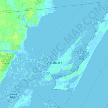
Name: Topografische Karte Chincoteague, Höhe, Relief.
Durchschnittliche Höhe: 1 m
Minimale Höhe: -5 m
Maximale Höhe: 24 m
Chincoteague is located at 37°56′5″N 75°22′4″W / 37.93472°N 75.36778°W / 37.93472; -75.36778 (37.934673, −75.367805). According to the United States Census Bureau, the town has a total area of 37.3 square miles (96.7 km2), of which 9.1 square miles (23.6 km2) is land and 28.2 square miles (73.1 km2), or 75.58%, is water. It lies at an elevation of three feet.
Andere topografische Karten
Klicken Sie auf eine Karte, um ihre Topografie, ihre Höhe und ihr Relief anzuzeigen.
Tangier Island
United States > Virginia > Accomack County > Tangier
Tangier Island, Tangier, Accomack County, Virginia, 23440, United States
Durchschnittliche Höhe: 2 m
Centerville
United States > Virginia > Accomack County
Centerville, Accomack County, Virginia, 23421, United States
Durchschnittliche Höhe: 10 m
Belle Haven
United States > Virginia > Accomack County
Belle Haven, Accomack County, Virginia, United States
Durchschnittliche Höhe: 8 m
Wattsville
United States > Virginia > Accomack County
Wattsville, Accomack County, Virginia, 23483, United States
Durchschnittliche Höhe: 11 m
Shields
United States > Virginia > Accomack County
Shields, Accomack County, Virginia, 23306, United States
Durchschnittliche Höhe: 6 m
Folly Creek
United States > Virginia > Accomack County
Folly Creek, Accomack County, Virginia, United States
Durchschnittliche Höhe: 4 m
Accomac
United States > Virginia > Accomack County
Accomac, Accomack County, Virginia, United States
Durchschnittliche Höhe: 12 m
Wachapreague
United States > Virginia > Accomack County
Wachapreague, Accomack County, Virginia, 23480, United States
Durchschnittliche Höhe: 1 m
Boston
United States > Virginia > Accomack County
Boston, Accomack County, Virginia, 23420, United States
Durchschnittliche Höhe: 6 m
Lee Mont
United States > Virginia > Accomack County
Lee Mont, Accomack County, Virginia, 23357, United States
Durchschnittliche Höhe: 6 m
Franklin City
United States > Virginia > Accomack County
Franklin City, Accomack County, Virginia, 23356, United States
Durchschnittliche Höhe: 1 m
Bloxom
United States > Virginia > Accomack County > Bloxom
Bloxom, Accomack County, Virginia, United States
Durchschnittliche Höhe: 9 m
Sanford
United States > Virginia > Accomack County > Sanford
Sanford, Accomack County, Virginia, 23426, United States
Durchschnittliche Höhe: 1 m
Deep Creek
United States > Virginia > Accomack County
Deep Creek, Accomack County, Virginia, United States
Durchschnittliche Höhe: 1 m
Parksley
United States > Virginia > Accomack County > Parksley
Parksley, Accomack County, Virginia, United States
Durchschnittliche Höhe: 11 m
Onancock
United States > Virginia > Accomack County
Onancock, Accomack County, Virginia, United States
Durchschnittliche Höhe: 6 m
Harborton
United States > Virginia > Accomack County
Harborton, Accomack County, Virginia, 23389, United States
Durchschnittliche Höhe: 2 m
Pungoteague
United States > Virginia > Accomack County
Pungoteague, Accomack County, Virginia, 23422, United States
Durchschnittliche Höhe: 7 m
Old Beach
United States > Virginia > Accomack County
Old Beach, Accomack County, Virginia, United States
Durchschnittliche Höhe: 2 m