
Topografische Karte Gaylord
Interaktive Karte
Klicken Sie auf die Karte, um die Höhe anzuzeigen.
Über diese Karte
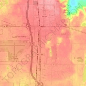
Name: Topografische Karte Gaylord, Höhe, Relief.
Ort: Gaylord, Otsego County, Michigan, United States (44.98712 -84.72699 45.04505 -84.64933)
Durchschnittliche Höhe: 401 m
Minimale Höhe: 323 m
Maximale Höhe: 424 m
Gaylord became a city in 1922. The change from village to city required a vote by town residents. For reasons that are unclear, the margin of passage was a very close 21 votes — 114 people in favor to 93 against. John Hamilton was elected the first mayor of Gaylord. Over the years, the community continued to grow, in part, because of its location. Gaylord’s Main Street was the intersection of U.S. 27 and M-32. These major roads brought both through-traffic and travelers to Gaylord. Gas stations, restaurants, and lodging establishments sprung up to accommodate local shoppers as well as visitors enjoying the area’s attractions. Long before Gaylord was the Alpine Village or the Golf Mecca, it promoted itself as the Top of Michigan and, later, the ski capital of Michigan. Both of these marketing endeavors were based on the area's natural features and reflected the importance of tourism as an economic development strategy. With an altitude of 1,394 feet above sea level, Gaylord held the distinction of being the city of highest elevation in Michigan’s Lower Peninsula. The abundant winter snowfall and steep hills nearby made downhill skiing a logical focus for efforts to attract recreational visitors to the area.
Andere topografische Karten
Klicken Sie auf eine Karte, um ihre Topografie, ihre Höhe und ihr Relief anzuzeigen.
Elmira
United States > Michigan > Otsego County
Elmira, Elmira Township, Otsego County, Michigan, 49730, United States
Durchschnittliche Höhe: 389 m
Vanderbilt
United States > Michigan > Otsego County
Vanderbilt, Corwith Township, Otsego County, Michigan, 49795, United States
Durchschnittliche Höhe: 334 m
Knowlton Lake
United States > Michigan > Otsego County
Knowlton Lake, Bagley Township, Otsego County, Michigan, United States
Durchschnittliche Höhe: 399 m
Hayes Township
United States > Michigan > Otsego County
Hayes Township, Otsego County, Michigan, United States
Durchschnittliche Höhe: 407 m
Lake Marjory
United States > Michigan > Otsego County
Lake Marjory, Otsego Lake Township, Otsego County, Michigan, United States
Durchschnittliche Höhe: 404 m