
Topografische Karte Midland Township
Interaktive Karte
Klicken Sie auf die Karte, um die Höhe anzuzeigen.
Über diese Karte
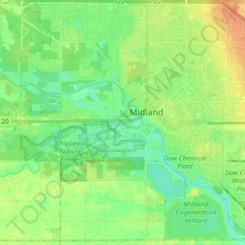
Name: Topografische Karte Midland Township, Höhe, Relief.
Ort: Midland Township, Midland County, Michigan, United States (43.56854 -84.29072 43.65469 -84.16717)
Durchschnittliche Höhe: 191 m
Minimale Höhe: 178 m
Maximale Höhe: 211 m
Andere topografische Karten
Klicken Sie auf eine Karte, um ihre Topografie, ihre Höhe und ihr Relief anzuzeigen.
Coleman
United States > Michigan > Midland County
Coleman, Midland County, Michigan, United States
Durchschnittliche Höhe: 231 m
Hope
United States > Michigan > Midland County
Hope, Hope Township, Midland County, Michigan, 48628, United States
Durchschnittliche Höhe: 205 m
Warren Township
United States > Michigan > Midland County
Warren Township, Midland County, Michigan, 48618, United States
Durchschnittliche Höhe: 223 m
Mills Township
United States > Michigan > Midland County
Mills Township, Midland County, Michigan, United States
Durchschnittliche Höhe: 207 m
Midland
United States > Michigan > Midland County
Midland, Midland County, Michigan, United States
Durchschnittliche Höhe: 194 m
Greendale Township
United States > Michigan > Midland County
Greendale Township, Midland County, Michigan, United States
Durchschnittliche Höhe: 208 m