
Topografische Karte Bergland Township
Interaktive Karte
Klicken Sie auf die Karte, um die Höhe anzuzeigen.
Über diese Karte
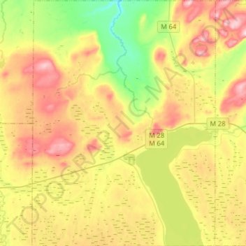
Name: Topografische Karte Bergland Township, Höhe, Relief.
Durchschnittliche Höhe: 407 m
Minimale Höhe: 296 m
Maximale Höhe: 537 m
Andere topografische Karten
Klicken Sie auf eine Karte, um ihre Topografie, ihre Höhe und ihr Relief anzuzeigen.
Trout Creek
United States > Michigan > Ontonagon County
Trout Creek, Stannard Township, Ontonagon County, Michigan, United States
Durchschnittliche Höhe: 336 m
Rockland Township
United States > Michigan > Ontonagon County
Rockland Township, Ontonagon County, Michigan, 49960, United States
Durchschnittliche Höhe: 310 m
Porcupine Mountains Wilderness State Park
United States > Michigan > Ontonagon County
Porcupine Mountains Wilderness State Park, Ontonagon Township, Ontonagon County, Michigan, 49953, United States
Durchschnittliche Höhe: 304 m
Ontonagon Township
United States > Michigan > Ontonagon County
Ontonagon Township, Ontonagon County, Michigan, 49953, United States
Durchschnittliche Höhe: 238 m
Silver City
United States > Michigan > Ontonagon County
Silver City, Carp Lake Township, Ontonagon County, Michigan, United States
Durchschnittliche Höhe: 188 m
Bruce Crossing
United States > Michigan > Ontonagon County
Bruce Crossing, Stannard Township, Ontonagon County, Michigan, 49912, United States
Durchschnittliche Höhe: 349 m
Robbins
United States > Michigan > Ontonagon County
Robbins, Haight Township, Ontonagon County, Michigan, United States
Durchschnittliche Höhe: 419 m
White Pine
United States > Michigan > Ontonagon County
White Pine, Carp Lake Township, Ontonagon County, Michigan, 49971, United States
Durchschnittliche Höhe: 270 m
Topaz
United States > Michigan > Ontonagon County
Topaz, Matchwood Township, Ontonagon County, Michigan, United States
Durchschnittliche Höhe: 386 m