
Topografische Karte Blue Ridge
Interaktive Karte
Klicken Sie auf die Karte, um die Höhe anzuzeigen.
Über diese Karte
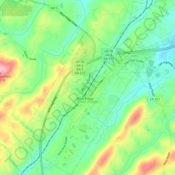
Name: Topografische Karte Blue Ridge, Höhe, Relief.
Ort: Blue Ridge, Fannin County, Georgia, United States (34.84741 -84.34159 34.88675 -84.29448)
Durchschnittliche Höhe: 535 m
Minimale Höhe: 472 m
Maximale Höhe: 639 m
Andere topografische Karten
Klicken Sie auf eine Karte, um ihre Topografie, ihre Höhe und ihr Relief anzuzeigen.
Aska
United States > Georgia > Fannin County
Aska, Fannin County, Georgia, United States
Durchschnittliche Höhe: 629 m
Greens Mill
United States > Georgia > Fannin County
Greens Mill, Fannin County, Georgia, 30513, United States
Durchschnittliche Höhe: 566 m
Dial
United States > Georgia > Fannin County
Dial, Fannin County, Georgia, United States
Durchschnittliche Höhe: 612 m
Colwell
United States > Georgia > Fannin County
Colwell, Fannin County, Georgia, United States
Durchschnittliche Höhe: 630 m
Higdon
United States > Georgia > Fannin County
Higdon, Fannin County, Georgia, 30541, United States
Durchschnittliche Höhe: 595 m
Lake Blue Ridge
United States > Georgia > Fannin County > Morganton
Lake Blue Ridge, Morganton, Fannin County, Georgia, United States
Durchschnittliche Höhe: 572 m
Cordell Mountain
United States > Georgia > Fannin County
Cordell Mountain, Fannin County, Georgia, 30559, United States
Durchschnittliche Höhe: 601 m
Springer Mountain
United States > Georgia > Fannin County
Springer Mountain, Fannin County, Georgia, United States
Durchschnittliche Höhe: 941 m
Ocoee River
United States > Georgia > Fannin County
Ocoee River, Fannin County, East Tennessee, Georgia, 30572, United States
Durchschnittliche Höhe: 579 m
McCaysville
United States > Georgia > Fannin County
McCaysville, Fannin County, Georgia, United States
Durchschnittliche Höhe: 484 m
Morganton
United States > Georgia > Fannin County
Morganton, Fannin County, Georgia, United States
Durchschnittliche Höhe: 538 m
Mineral Bluff
United States > Georgia > Fannin County
Mineral Bluff, Fannin County, Georgia, 30559, United States
Durchschnittliche Höhe: 516 m
Kyle
United States > Georgia > Fannin County
Kyle, Fannin County, Georgia, 30555, United States
Durchschnittliche Höhe: 508 m
Epworth
United States > Georgia > Fannin County > Epworth
Epworth, Fannin County, Georgia, 30555, United States
Durchschnittliche Höhe: 524 m
Loving
United States > Georgia > Fannin County > Loving
Loving, Fannin County, Georgia, 30560, United States
Durchschnittliche Höhe: 577 m