
Topografische Karte Bellevue
Interaktive Karte
Klicken Sie auf die Karte, um die Höhe anzuzeigen.
Über diese Karte
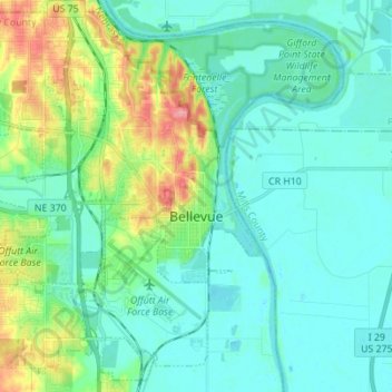
Name: Topografische Karte Bellevue, Höhe, Relief.
Ort: Bellevue, Sarpy County, Nebraska, United States (41.09278 -96.00926 41.19110 -95.87084)
Durchschnittliche Höhe: 315 m
Minimale Höhe: 288 m
Maximale Höhe: 385 m
Bellevue is located at an elevation of 1159 ft (353 m). According to the United States Census Bureau, the city has a total area of 16.02 square miles (41.49 km2), of which 15.85 square miles (41.05 km2) is land and 0.17 square miles (0.44 km2) is water. It is bounded on the east by the Missouri River.
Andere topografische Karten
Klicken Sie auf eine Karte, um ihre Topografie, ihre Höhe und ihr Relief anzuzeigen.
Chalco
United States > Nebraska > Sarpy County
Chalco, Sarpy County, Nebraska, 68138, United States
Durchschnittliche Höhe: 346 m
La Vista
United States > Nebraska > Sarpy County
La Vista, Sarpy County, Nebraska, 68128, United States
Durchschnittliche Höhe: 330 m
Fontenelle Forest
United States > Nebraska > Sarpy County > Bellevue
Fontenelle Forest, Bellevue, Sarpy County, Nebraska, 68123, United States
Durchschnittliche Höhe: 316 m
Papillion
United States > Nebraska > Sarpy County
Papillion, Sarpy County, Nebraska, 68046, United States
Durchschnittliche Höhe: 338 m
Prairie Queen Recreation Area
United States > Nebraska > Sarpy County > Papillion
Prairie Queen Recreation Area, Papillion, Sarpy County, Nebraska, United States
Durchschnittliche Höhe: 346 m
Gretna
United States > Nebraska > Sarpy County
Gretna, Sarpy County, Nebraska, 68028, United States
Durchschnittliche Höhe: 363 m
Springfield
United States > Nebraska > Sarpy County > Springfield
Springfield, Sarpy County, Nebraska, 68059, United States
Durchschnittliche Höhe: 344 m