
Topografische Karte Rapid City
Interaktive Karte
Klicken Sie auf die Karte, um die Höhe anzuzeigen.
Über diese Karte
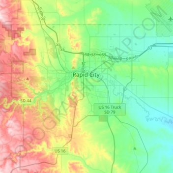
Name: Topografische Karte Rapid City, Höhe, Relief.
Ort: Rapid City, Pennington County, South Dakota, United States (43.99492 -103.32635 44.13679 -103.03791)
Durchschnittliche Höhe: 1.068 m
Minimale Höhe: 914 m
Maximale Höhe: 1.390 m
Rapid City is located at 44°04′34″N 103°13′42″W / 44.076188°N 103.228299°W / 44.076188; -103.228299. The downtown elevation of Rapid City is 3,202 feet (976 m). Rapid City is located in the shadow of Black Elk Peak, which at 7,242 feet (2,207 m), is the highest point east of the Rocky Mountains.
Andere topografische Karten
Klicken Sie auf eine Karte, um ihre Topografie, ihre Höhe und ihr Relief anzuzeigen.
Moon
United States > South Dakota > Pennington County
Moon, Pennington County, South Dakota, United States
Durchschnittliche Höhe: 1.938 m
Black Hills
United States > South Dakota > Pennington County
Black Hills, Pennington County, South Dakota, United States
Durchschnittliche Höhe: 1.894 m
Mount Rushmore
United States > South Dakota > Pennington County
Mount Rushmore, Pennington County, South Dakota, 57751, United States
Durchschnittliche Höhe: 1.562 m
Rapid Creek
United States > South Dakota > Pennington County
Rapid Creek, Pennington County, South Dakota, United States
Durchschnittliche Höhe: 1.689 m
Mount Rushmore National Memorial
United States > South Dakota > Pennington County
Mount Rushmore National Memorial, Pennington County, South Dakota, United States
Durchschnittliche Höhe: 1.528 m
Rapid Valley
United States > South Dakota > Pennington County > Rapid Valley
Rapid Valley, Pennington County, South Dakota, 57703-6649, United States
Durchschnittliche Höhe: 977 m