
Topografische Karte Lewiston
Interaktive Karte
Klicken Sie auf die Karte, um die Höhe anzuzeigen.
Über diese Karte
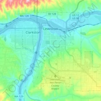
Name: Topografische Karte Lewiston, Höhe, Relief.
Ort: Lewiston, Nez Perce County, Idaho, 83501, United States (46.36165 -117.04659 46.43711 -116.91126)
Durchschnittliche Höhe: 334 m
Minimale Höhe: 219 m
Maximale Höhe: 758 m
According to the U.S. Census Bureau, the city has a total area of 18.04 square miles (46.72 km2), of which 17.23 square miles (44.63 km2) is land and 0.81 square miles (2.10 km2) is water. Downtown Lewiston, at elevations between 740 feet (230 m) and 780 feet (240 m), is only slightly higher in elevation than the river, about 741 ft (226 m), which was thirty feet (9 m) lower prior to the completion of the Lower Granite Dam. Away from downtown the terrain gains elevation quickly, as the steep riverbank highway of U.S. 95 north of Lewiston ascends to 2,756 feet (840 m).
Andere topografische Karten
Klicken Sie auf eine Karte, um ihre Topografie, ihre Höhe und ihr Relief anzuzeigen.
Lenore
United States > Idaho > Nez Perce County
Lenore, Nez Perce County, Idaho, United States
Durchschnittliche Höhe: 401 m
Lapwai
United States > Idaho > Nez Perce County
Lapwai, Nez Perce County, Idaho, 83540, United States
Durchschnittliche Höhe: 364 m
Culdesac
United States > Idaho > Nez Perce County > Culdesac
Culdesac, Nez Perce County, Idaho, United States
Durchschnittliche Höhe: 588 m
Upper Cache Creek Rapids
United States > Idaho > Nez Perce County
Upper Cache Creek Rapids, Nez Perce County, Idaho, United States
Durchschnittliche Höhe: 484 m