
Topografische Karte Mountain Home
Interaktive Karte
Klicken Sie auf die Karte, um die Höhe anzuzeigen.
Über diese Karte
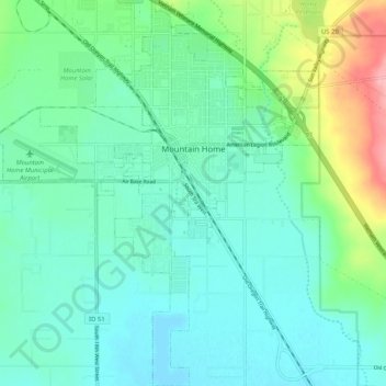
Name: Topografische Karte Mountain Home, Höhe, Relief.
Ort: Mountain Home, Elmore County, Idaho, United States (43.08667 -115.74727 43.16193 -115.65771)
Durchschnittliche Höhe: 967 m
Minimale Höhe: 940 m
Maximale Höhe: 1.056 m
Mountain Home is located at 43°8′13″N 115°41′40″W / 43.13694°N 115.69444°W / 43.13694; -115.69444 (43.136812, -115.694474), at an elevation of 3,146 feet (959 m) above sea level.
Andere topografische Karten
Klicken Sie auf eine Karte, um ihre Topografie, ihre Höhe und ihr Relief anzuzeigen.
Sugar Bowl
United States > Idaho > Elmore County
Sugar Bowl, Elmore County, Idaho, 83633, United States
Durchschnittliche Höhe: 799 m
Prairie
United States > Idaho > Elmore County
Prairie, Elmore County, Idaho, 83674, United States
Durchschnittliche Höhe: 1.486 m
Atlanta
United States > Idaho > Elmore County
Atlanta, Elmore County, Idaho, 83601, United States
Durchschnittliche Höhe: 1.820 m
Pine
United States > Idaho > Elmore County
Pine, Elmore County, Idaho, United States
Durchschnittliche Höhe: 1.462 m
Glenns Ferry
United States > Idaho > Elmore County > Glenns Ferry
Glenns Ferry, Elmore County, Idaho, 83623, United States
Durchschnittliche Höhe: 798 m
Mountain Home
United States > Idaho > Elmore County > Mountain Home
Mountain Home, Elmore County, Idaho, 83647, United States
Durchschnittliche Höhe: 973 m