
Topografische Karte Hagerstown
Interaktive Karte
Klicken Sie auf die Karte, um die Höhe anzuzeigen.
Über diese Karte
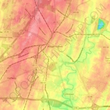
Name: Topografische Karte Hagerstown, Höhe, Relief.
Ort: Hagerstown, Washington County, Maryland, United States (39.60003 -77.77309 39.67373 -77.67228)
Durchschnittliche Höhe: 170 m
Minimale Höhe: 102 m
Maximale Höhe: 204 m
Hagerstown has a distinct topography, formed by stone ridges running from northeast to southwest through the center of town. Geography accordingly bounds its neighborhoods. These ridges consist of upper Stonehenge limestone. Many of the older buildings were built from this stone, which is easily quarried and dressed onsite. It whitens in weathering and the edgewise conglomerate and wavy laminae become distinctly visible, giving a handsome and uniquely "Cumberland Valley" appearance. Several of Hagerstown's churches are constructed of Stonehenge limestone. Its value and beauty as building rock may be seen particularly in St. John's Episcopal Church on West Antietam Street and the Presbyterian Church at the corner of Washington and Prospect Streets. Brick and concrete eventually displaced this native stone in the construction process.
Andere topografische Karten
Klicken Sie auf eine Karte, um ihre Topografie, ihre Höhe und ihr Relief anzuzeigen.
Antietam
United States > Maryland > Washington County
Antietam, Washington County, Maryland, 21782, United States
Durchschnittliche Höhe: 123 m
Keedysville
United States > Maryland > Washington County
Keedysville, Washington County, Maryland, United States
Durchschnittliche Höhe: 129 m
Weverton
United States > Maryland > Washington County
Weverton, Washington County, Maryland, 21758, United States
Durchschnittliche Höhe: 153 m
Halfway
United States > Maryland > Washington County
Halfway, Washington County, Maryland, United States
Durchschnittliche Höhe: 171 m
Williamsport
United States > Maryland > Washington County
Williamsport, Washington County, Maryland, United States
Durchschnittliche Höhe: 127 m
Robinwood
United States > Maryland > Washington County > Robinwood
Robinwood, Washington County, Maryland, United States
Durchschnittliche Höhe: 175 m
Cavetown
United States > Maryland > Washington County
Cavetown, Washington County, Maryland, 21720, United States
Durchschnittliche Höhe: 259 m
Wilson-Conococheague
United States > Maryland > Washington County
Wilson-Conococheague, Washington County, Maryland, United States
Durchschnittliche Höhe: 140 m
Paramount-Long Meadow
United States > Maryland > Washington County > Paramount
Paramount-Long Meadow, Paramount, Washington County, Maryland, 21742, United States
Durchschnittliche Höhe: 177 m
Cascade
United States > Maryland > Washington County
Cascade, Washington County, Maryland, 21719, United States
Durchschnittliche Höhe: 436 m
Antietam National Battlefield
United States > Maryland > Washington County > Sharpsburg
Antietam National Battlefield, Sharpsburg, Washington County, Maryland, 21782, United States
Durchschnittliche Höhe: 147 m
Big Pool Lake
United States > Maryland > Washington County > Big Pool
Big Pool Lake, Big Pool, Washington County, Maryland, United States
Durchschnittliche Höhe: 143 m
Saint James Village
United States > Maryland > Washington County
Saint James Village, Washington County, Maryland, 21746, United States
Durchschnittliche Höhe: 154 m
Sharpsburg
United States > Maryland > Washington County > Sharpsburg
Sharpsburg, Washington County, Maryland, United States
Durchschnittliche Höhe: 138 m
Pleasant Valley
United States > Maryland > Washington County
Pleasant Valley, Washington County, Maryland, 21783, United States
Durchschnittliche Höhe: 462 m
Smithsburg
United States > Maryland > Washington County
Smithsburg, Washington County, Maryland, 21783, United States
Durchschnittliche Höhe: 244 m
Dargan
United States > Maryland > Washington County
Dargan, Washington County, Maryland, 21782, United States
Durchschnittliche Höhe: 158 m
Mount Lena
United States > Maryland > Washington County > Mount Lena
Mount Lena, Washington County, Maryland, United States
Durchschnittliche Höhe: 243 m
Hancock
United States > Maryland > Washington County > Hancock > Hancock
Hancock, Washington County, Maryland, 21750, United States
Durchschnittliche Höhe: 166 m
Hillside
United States > Maryland > Washington County > Hillside
Hillside, Washington County, Maryland, United States
Durchschnittliche Höhe: 181 m
Greenbrier State Park
United States > Maryland > Washington County > San Mar
Greenbrier State Park, Mountain Laurel Road, San Mar, Washington County, Maryland, 21713, United States
Durchschnittliche Höhe: 305 m
Boonsboro
United States > Maryland > Washington County
Boonsboro, Washington County, Maryland, 21713, United States
Durchschnittliche Höhe: 193 m
Clear Spring
United States > Maryland > Washington County
Clear Spring, Washington County, Maryland, United States
Durchschnittliche Höhe: 176 m
Hancock
United States > Maryland > Washington County
Hancock, Washington County, Maryland, United States
Durchschnittliche Höhe: 167 m
Bakersville
United States > Maryland > Washington County
Bakersville, Washington County, Maryland, 21733, United States
Durchschnittliche Höhe: 137 m