
Topografische Karte Shillong
Interaktive Karte
Klicken Sie auf die Karte, um die Höhe anzuzeigen.
Über diese Karte
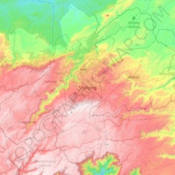
Name: Topografische Karte Shillong, Höhe, Relief.
Durchschnittliche Höhe: 1.351 m
Minimale Höhe: 656 m
Maximale Höhe: 1.957 m
HQ Eastern Air Command (HQ, EAC) was shifted to Shillong on 10 Jun 63 from Kolkata and housed in the old buildings located at Nonglyer village at Upper Shillong, some 10 km from (Lower) Shillong, but at a greater altitude of around 6,000 feet AMSL. Initially a British military base, it was taken over by No. 58 Gorkha Regiment of the Indian Army post Independence in 1947. The Regiment was redeployed after the Sino-Indian War of 1962, making way for the IAF to step in. Only helicopters can operate from HQ, EAC, using a 12.7 hectare (31.3 acre) helipad.
Andere topografische Karten
Klicken Sie auf eine Karte, um ihre Topografie, ihre Höhe und ihr Relief anzuzeigen.
Sonapani Waterfall Cliff
India > Meghalaya > Mylliem > Shillong
Sonapani Waterfall Cliff, Lower Mawprem, Shillong, Mylliem, East Khasi Hills District, Meghalaya, 793001, India
Durchschnittliche Höhe: 1.402 m