
Topografische Karte Massachusetts
Interaktive Karte
Klicken Sie auf die Karte, um die Höhe anzuzeigen.
Über diese Karte
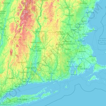
Name: Topografische Karte Massachusetts, Höhe, Relief.
Ort: Massachusetts, United States (41.18886 -73.50821 42.88678 -69.86010)
Durchschnittliche Höhe: 128 m
Minimale Höhe: -7 m
Maximale Höhe: 1.159 m
Despite its small size, Massachusetts features numerous topographically distinctive regions. The large coastal plain of the Atlantic Ocean in the eastern section of the state contains Greater Boston, along with most of the state's population, as well as the distinctive Cape Cod peninsula. To the west lies the hilly, rural region of Central Massachusetts, and beyond that, the Connecticut River Valley. Along the western border of Western Massachusetts lies the highest elevated part of the state, the Berkshires, forming a portion of the northern terminus of the Appalachian Mountains.
Andere topografische Karten
Klicken Sie auf eine Karte, um ihre Topografie, ihre Höhe und ihr Relief anzuzeigen.
Los Angeles
Los Angeles, California, United States
Durchschnittliche Höhe: 241 m
Madison
United States > Wisconsin > Dane County
Madison, Dane County, Wisconsin, United States
Durchschnittliche Höhe: 284 m
Jacksonville
United States > Florida > Duval County
Jacksonville, Duval County, Florida, United States
Durchschnittliche Höhe: 10 m
Brooklyn
United States > New York > New York
Brooklyn, Kings County, New York, United States
Durchschnittliche Höhe: 9 m
Kent County
Kent County, Michigan, United States
Durchschnittliche Höhe: 240 m
Staten Island
United States > New York > New York
Staten Island, Richmond County, New York, United States
Durchschnittliche Höhe: 9 m
Lancaster County
Lancaster County, Pennsylvania, United States
Durchschnittliche Höhe: 158 m
Sarasota
United States > Florida > Sarasota County
Sarasota, Sarasota County, Florida, United States
Durchschnittliche Höhe: 7 m
Sequim
United States > Washington > Clallam County
Sequim, Clallam County, Washington, United States
Durchschnittliche Höhe: 88 m
Fairfax County
Fairfax County, Virginia, United States
Durchschnittliche Höhe: 75 m
Allegheny County
Allegheny County, Pennsylvania, United States
Durchschnittliche Höhe: 325 m
Appalachian Mountains
United States > North Carolina > Yancey County
Appalachian Mountains, Yancey County, North Carolina, United States
Durchschnittliche Höhe: 1.463 m
Boulder
United States > Colorado > Boulder County
Boulder, Boulder County, Colorado, United States
Durchschnittliche Höhe: 1.785 m
Seattle
United States > Washington > King County
Seattle, King County, Washington, United States
Durchschnittliche Höhe: 40 m
Miami-Dade County
Miami-Dade County, Florida, United States
Durchschnittliche Höhe: 3 m
Spokane
United States > Washington > Spokane County
Spokane, Spokane County, Washington, United States
Durchschnittliche Höhe: 655 m
Central Park
United States > New York > New York County > New York
Central Park, New York County, New York, United States
Durchschnittliche Höhe: 26 m
Rudyard
United States > Michigan > Chippewa County
Rudyard, Rudyard Township, Chippewa County, Michigan, United States
Durchschnittliche Höhe: 209 m
Taos
United States > New Mexico > Taos County
Taos, Taos County, New Mexico, United States
Durchschnittliche Höhe: 2.180 m
Puget Sound
United States > Washington > Edmonds
Puget Sound, Admiral Way, Edmonds, Snohomish County, Washington, 98020, United States
Durchschnittliche Höhe: 0 m