
Topografische Karte Mississippi River
Interaktive Karte
Klicken Sie auf die Karte, um die Höhe anzuzeigen.
Über diese Karte
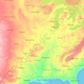
Name: Topografische Karte Mississippi River, Höhe, Relief.
Ort: Mississippi River, United States (29.15784 -95.24694 47.49749 -89.09884)
Durchschnittliche Höhe: 344 m
Minimale Höhe: -3 m
Maximale Höhe: 1.927 m
The uppermost lock and dam on the Upper Mississippi River is the Upper St. Anthony Falls Lock and Dam in Minneapolis. Above the dam, the river's elevation is 799 feet (244 m). Below the dam, the river's elevation is 750 feet (230 m). This 49-foot (15 m) drop is the largest of all the Mississippi River locks and dams. The origin of the dramatic drop is a waterfall preserved adjacent to the lock under an apron of concrete. Saint Anthony Falls is the only true waterfall on the entire Mississippi River. The water elevation continues to drop steeply as it passes through the gorge carved by the waterfall.
Andere topografische Karten
Klicken Sie auf eine Karte, um ihre Topografie, ihre Höhe und ihr Relief anzuzeigen.
Pinellas County
Pinellas County, Florida, United States
Durchschnittliche Höhe: 4 m
Roseville
United States > California > Placer County
Roseville, Placer County, California, United States
Durchschnittliche Höhe: 61 m
Lynnwood
United States > Washington > Snohomish County
Lynnwood, Snohomish County, Washington, 98037, United States
Durchschnittliche Höhe: 121 m
Largo
United States > Florida > Pinellas County
Largo, Pinellas County, Florida, United States
Durchschnittliche Höhe: 9 m
Wake County
United States > North Carolina
Wake County, North Carolina, United States
Durchschnittliche Höhe: 96 m
Ocean County
Ocean County, New Jersey, United States
Durchschnittliche Höhe: 15 m
Redwood City
United States > California > San Mateo County
Redwood City, San Mateo County, California, United States
Durchschnittliche Höhe: 32 m
Rudeston
United States > New York > Hamilton County
Rudeston, Town of Arietta, Hamilton County, New York, United States
Durchschnittliche Höhe: 533 m
Fargo
United States > North Dakota > Cass County
Fargo, Cass County, North Dakota, United States
Durchschnittliche Höhe: 277 m
Hennepin County
Hennepin County, Minnesota, United States
Durchschnittliche Höhe: 280 m
San Antonio
United States > Texas > Bexar County
San Antonio, Bexar County, Texas, United States
Durchschnittliche Höhe: 247 m
Puyallup
United States > Washington > Pierce County
Puyallup, Pierce County, Washington, United States
Durchschnittliche Höhe: 66 m
Santa Ana Pueblo
United States > New Mexico > Sandoval County
Santa Ana Pueblo, Sandoval County, New Mexico, United States
Durchschnittliche Höhe: 1.576 m
Hollis Park
United States > Arizona > Maricopa County > Tempe
Hollis Park, Tempe, Maricopa County, Arizona, United States
Durchschnittliche Höhe: 362 m
Everett
United States > Washington > Snohomish County
Everett, Snohomish County, Washington, United States
Durchschnittliche Höhe: 66 m
Moore County
United States > North Carolina
Moore County, North Carolina, United States
Durchschnittliche Höhe: 127 m
Baltimore County
Baltimore County, Maryland, United States
Durchschnittliche Höhe: 123 m
Shawnee County
Shawnee County, Kansas, United States
Durchschnittliche Höhe: 315 m
Beaverton
United States > Oregon > Washington County
Beaverton, Washington County, Oregon, United States
Durchschnittliche Höhe: 106 m
Starks
United States > Maine > Somerset County
Starks, Somerset County, Maine, United States
Durchschnittliche Höhe: 129 m
Good
United States > Virginia > Frederick County
Good, Frederick County, Virginia, 22625, United States
Durchschnittliche Höhe: 356 m
Hickory
United States > North Carolina > Catawba County
Hickory, Catawba County, North Carolina, United States
Durchschnittliche Höhe: 317 m
Litchfield County
United States > Connecticut > Northwest Hills Planning Region
Litchfield County, Northwest Hills Planning Region, Connecticut, United States
Durchschnittliche Höhe: 252 m
Little Egg Harbor
United States > New Jersey > Ocean County > Little Egg Harbor Township
Little Egg Harbor, Little Egg Harbor Township, Ocean County, New Jersey, United States
Durchschnittliche Höhe: 2 m
Park Ridge
United States > Illinois > Cook County
Park Ridge, Maine Township, Cook County, Illinois, 60068, United States
Durchschnittliche Höhe: 198 m
Crescent City
United States > California > Del Norte County
Crescent City, Del Norte County, California, United States
Durchschnittliche Höhe: 31 m
Evergreen
United States > Colorado > Jefferson County
Evergreen, Jefferson County, Colorado, 80457, United States
Durchschnittliche Höhe: 2.301 m
Whidbey Island
United States > Washington > Island County
Whidbey Island, Island County, Washington, United States
Durchschnittliche Höhe: 45 m
Bennet Park
United States > Michigan > Eaton County > Charlotte
Bennet Park, Charlotte, Eaton Township, Eaton County, Michigan, United States
Durchschnittliche Höhe: 277 m
Easton
United States > Massachusetts > Bristol County
Easton, Bristol County, Massachusetts, United States
Durchschnittliche Höhe: 47 m
Newtown
United States > Connecticut > Western Connecticut Planning Region
Newtown, Western Connecticut Planning Region, Connecticut, United States
Durchschnittliche Höhe: 147 m
Lake Of The Ozarks
United States > Missouri > Camden County > Osage Beach
Lake Of The Ozarks, Osage Beach, Camden County, Missouri, 65079, United States
Durchschnittliche Höhe: 265 m
Tampa
United States > Florida > Hillsborough County
Tampa, Hillsborough County, Florida, United States
Durchschnittliche Höhe: 11 m
Freeburn
United States > Kentucky > Pike County
Freeburn, Pike County, Kentucky, 41528, United States
Durchschnittliche Höhe: 342 m
Mount Ida
United States > Arkansas > Montgomery County
Mount Ida, Montgomery County, Arkansas, United States
Durchschnittliche Höhe: 215 m
Gloucester
United States > Massachusetts > Essex County > Gloucester
Gloucester, Essex County, Massachusetts, 01930, United States
Durchschnittliche Höhe: 15 m
Highlands
United States > North Carolina > Macon County
Highlands, Macon County, North Carolina, 28741, United States
Durchschnittliche Höhe: 1.116 m
Town of Perry
United States > New York > Wyoming County
Town of Perry, Wyoming County, New York, 14530, United States
Durchschnittliche Höhe: 403 m
Little Blue Lake
United States > Washington > Skamania County
Little Blue Lake, Skamania County, Washington, United States
Durchschnittliche Höhe: 158 m
Cloud Forest
United States > Florida > Miami-Dade County
Cloud Forest, Miami-Dade County, Florida, 33177, United States
Durchschnittliche Höhe: 6 m
Garfield County
Garfield County, Utah, United States
Durchschnittliche Höhe: 1.907 m
Quilcene
United States > Washington > Jefferson County > Quilcene
Quilcene, Jefferson County, Washington, United States
Durchschnittliche Höhe: 268 m
Brandon
United States > Mississippi > Rankin County
Brandon, Rankin County, Mississippi, 39042, United States
Durchschnittliche Höhe: 118 m
Shooks Gap
United States > Tennessee > Sevier County
Shooks Gap, Seymour, Sevier County, East Tennessee, Tennessee, 37865, United States
Durchschnittliche Höhe: 327 m
South Cove Park
United States > Washington > King County > Issaquah
South Cove Park, Issaquah, King County, Washington, United States
Durchschnittliche Höhe: 40 m
City of Ogdensburg
United States > New York > Saint Lawrence County
City of Ogdensburg, Saint Lawrence County, New York, United States
Durchschnittliche Höhe: 85 m
Pushmataha County
Pushmataha County, Oklahoma, United States
Durchschnittliche Höhe: 240 m
Errol
United States > New Hampshire > Coos County
Errol, Coös County, New Hampshire, United States
Durchschnittliche Höhe: 453 m
Sibley County
Sibley County, Minnesota, United States
Durchschnittliche Höhe: 304 m