
Topografische Karte Bowery Bay
Interaktive Karte
Klicken Sie auf die Karte, um die Höhe anzuzeigen.
Über diese Karte
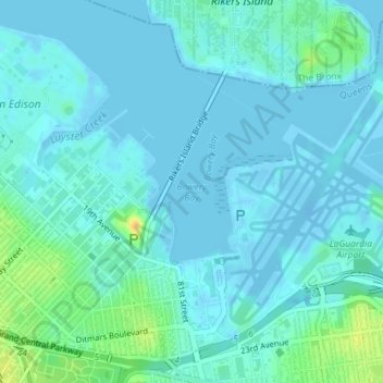
Name: Topografische Karte Bowery Bay, Höhe, Relief.
Ort: Bowery Bay, Queens County, New York, 11371, United States (40.77838 -73.88824 40.77848 -73.88814)
Durchschnittliche Höhe: 5 m
Minimale Höhe: -15 m
Maximale Höhe: 28 m
Andere topografische Karten
Klicken Sie auf eine Karte, um ihre Topografie, ihre Höhe und ihr Relief anzuzeigen.
Brooklyn
United States > New York > New York
Brooklyn, Kings County, New York, United States
Durchschnittliche Höhe: 9 m
Staten Island
United States > New York > New York
Staten Island, Richmond County, New York, United States
Durchschnittliche Höhe: 9 m
Bronx County
United States > New York > New York
Bronx County, The Bronx, New York, United States
Durchschnittliche Höhe: 21 m
Queens County
United States > New York > New York
Queens County, New York, United States
Durchschnittliche Höhe: 11 m
Kaiser Park
United States > New York > New York
Kaiser Park, Brooklyn, Kings County, New York, United States
Durchschnittliche Höhe: 2 m
Franz Sigel Park
United States > New York > New York
Franz Sigel Park, Bronx County, The Bronx, New York, United States
Durchschnittliche Höhe: 16 m
Emerson Hill
United States > New York > New York
Emerson Hill, New York, 10304, United States
Durchschnittliche Höhe: 53 m
Sylvan Water
United States > New York > New York
Sylvan Water, Brooklyn, Kings County, New York, United States
Durchschnittliche Höhe: 25 m
Jackie Robinson Park
United States > New York > New York
Jackie Robinson Park, Brooklyn, Kings County, New York, United States
Durchschnittliche Höhe: 22 m
Queens
United States > New York > New York
Queens, Queens County, New York, United States
Durchschnittliche Höhe: 12 m
Lawrence Point
United States > New York > New York
Lawrence Point, Queens County, New York, 11105, United States
Durchschnittliche Höhe: 4 m
The Bronx
United States > New York > New York
The Bronx, New York, United States
Durchschnittliche Höhe: 23 m
Flushing Bay
United States > New York > New York
Flushing Bay, Queens County, New York, 11356, United States
Durchschnittliche Höhe: 4 m
Gowanus Canal
United States > New York > New York
Gowanus Canal, Kings County, New York, 11231, United States
Durchschnittliche Höhe: 11 m
Fort Greene Park
United States > New York > New York
Fort Greene Park, Brooklyn, Kings County, New York, United States
Durchschnittliche Höhe: 17 m
New York County
United States > New York > New York
New York County, New York, United States
Durchschnittliche Höhe: 16 m
Prospect Park
United States > New York > New York
Prospect Park, Kings County, New York, United States
Durchschnittliche Höhe: 34 m
Flushing Meadows-Corona Park
United States > New York > New York
Flushing Meadows-Corona Park, New York, United States
Durchschnittliche Höhe: 15 m
Willets Point
United States > New York > New York
Willets Point, Queens County, New York, 11359, United States
Durchschnittliche Höhe: 2 m
Jamaica Bay Wildlife Refuge
United States > New York > New York
Jamaica Bay Wildlife Refuge, Queens County, New York, 11694, United States
Durchschnittliche Höhe: 1 m
Flushing Meadows Scenic Viewpoint
United States > New York > New York
Flushing Meadows Scenic Viewpoint, Pat Dolan Trail, Kew Gardens, Queens, New York, 11375, United States
Durchschnittliche Höhe: 22 m
Coastline access
United States > New York > New York
Coastline access, Brooklyn, Kings County, New York, United States
Durchschnittliche Höhe: 3 m
Richmond County
United States > New York > New York
Richmond County, New York, United States
Durchschnittliche Höhe: 9 m
Kings County
United States > New York > New York
Kings County, New York, United States
Durchschnittliche Höhe: 9 m
Barren Island
United States > New York > New York
Barren Island, New York, 11697, United States
Durchschnittliche Höhe: 16 m