
Topografische Karte Junagadh
Interaktive Karte
Klicken Sie auf die Karte, um die Höhe anzuzeigen.
Über diese Karte
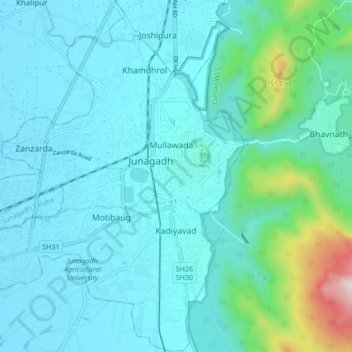
Name: Topografische Karte Junagadh, Höhe, Relief.
Durchschnittliche Höhe: 163 m
Minimale Höhe: 54 m
Maximale Höhe: 853 m
Junagadh city is located at 21°31′N 70°28′E / 21.52°N 70.47°E / 21.52; 70.47 at the foot of Mount Girnar, with the Arabian sea to the southwest, Porbandar to the north, and Amreli to the east. It has an average elevation of 107 metres (351 ft).