
Topografische Karte City of Syracuse
Interaktive Karte
Klicken Sie auf die Karte, um die Höhe anzuzeigen.
Über diese Karte
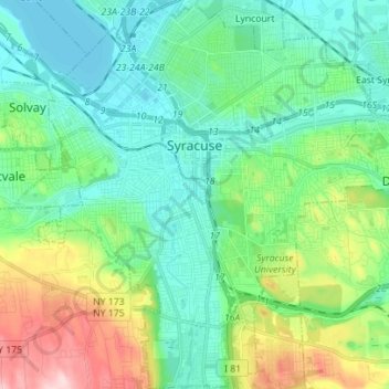
Name: Topografische Karte City of Syracuse, Höhe, Relief.
Ort: City of Syracuse, Onondaga County, New York, United States (42.98417 -76.20463 43.08612 -76.07427)
Durchschnittliche Höhe: 172 m
Minimale Höhe: 109 m
Maximale Höhe: 354 m
Andere topografische Karten
Klicken Sie auf eine Karte, um ihre Topografie, ihre Höhe und ihr Relief anzuzeigen.
Town of Cicero
United States > New York > Onondaga County
Town of Cicero, Onondaga County, New York, United States
Durchschnittliche Höhe: 120 m
Hiawatha Lake
United States > New York > Onondaga County > City of Syracuse
Hiawatha Lake, Strathmore, City of Syracuse, Onondaga County, New York, United States
Durchschnittliche Höhe: 151 m
Town of Manlius
United States > New York > Onondaga County
Town of Manlius, Onondaga County, New York, United States
Durchschnittliche Höhe: 179 m
Town of Clay
United States > New York > Onondaga County
Town of Clay, Onondaga County, New York, United States
Durchschnittliche Höhe: 120 m
Camillus
United States > New York > Onondaga County > Camillus
Camillus, Onondaga County, New York, United States
Durchschnittliche Höhe: 177 m
Pompey
United States > New York > Onondaga County > Town of Pompey > Pompey
Pompey, Town of Pompey, Onondaga County, New York, 13138, United States
Durchschnittliche Höhe: 450 m
Apulia
United States > New York > Onondaga County > Town of Fabius > Apulia
Apulia, Town of Fabius, Onondaga County, New York, 13020, United States
Durchschnittliche Höhe: 409 m