
Topografische Karte Big Bear Lake
Interaktive Karte
Klicken Sie auf die Karte, um die Höhe anzuzeigen.
Über diese Karte
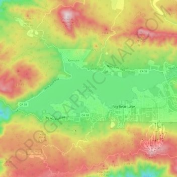
Name: Topografische Karte Big Bear Lake, Höhe, Relief.
Durchschnittliche Höhe: 2.209 m
Minimale Höhe: 1.905 m
Maximale Höhe: 2.544 m
At a surface elevation of 6,743 ft (2,055 m) above sea level, it has an east-west length of approximately seven miles (11 km) and is approximately 2.5 miles (4.0 km) at its widest measurement, though the lake's width mostly averages a little more than 1⁄2 mi (0.8 km). These approximations are based on the lake having an optimum retainable water level. At dam's end, Big Bear measures its deepest water at 72 feet (22 m).
Andere topografische Karten
Klicken Sie auf eine Karte, um ihre Topografie, ihre Höhe und ihr Relief anzuzeigen.
Moonridge
United States > California > San Bernardino County > Big Bear Lake
Moonridge, Big Bear Lake, San Bernardino County, CAL Fire Southern Region, California, 92314, United States
Durchschnittliche Höhe: 2.211 m