
Topografische Karte Post Falls
Interaktive Karte
Klicken Sie auf die Karte, um die Höhe anzuzeigen.
Über diese Karte
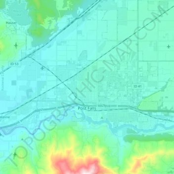
Name: Topografische Karte Post Falls, Höhe, Relief.
Ort: Post Falls, Kootenai County, Idaho, 83854, United States (47.69255 -117.04179 47.75945 -116.85641)
Durchschnittliche Höhe: 710 m
Minimale Höhe: 619 m
Maximale Höhe: 1.295 m
Post Falls is located on the Rathdrum Prairie, along the Washington–Idaho border. It is bounded by Coeur d’Alene to the east, Stateline and the state of Washington to the west, and the Spokane River to the south. Post Falls is 20 miles (32 km) east of Spokane and approximately 100 miles (160 km) south of the Canada–United States border. The elevation of the city is 2,182 feet (665 m) above sea level.
Andere topografische Karten
Klicken Sie auf eine Karte, um ihre Topografie, ihre Höhe und ihr Relief anzuzeigen.
Coeur d'Alene
United States > Idaho > Kootenai County
Coeur d'Alene, Kootenai County, Idaho, 83815, United States
Durchschnittliche Höhe: 719 m
Hauser
United States > Idaho > Kootenai County
Hauser, Kootenai County, Idaho, United States
Durchschnittliche Höhe: 712 m
Bayview
United States > Idaho > Kootenai County
Bayview, Kootenai County, Idaho, United States
Durchschnittliche Höhe: 733 m
Farragut State Park
United States > Idaho > Kootenai County > Bayview
Farragut State Park, Bayview, Kootenai County, Idaho, United States
Durchschnittliche Höhe: 723 m
Fernan Saddle
United States > Idaho > Kootenai County
Fernan Saddle, Kootenai County, Idaho, United States
Durchschnittliche Höhe: 1.201 m
Lake Coeur d'Alene
United States > Idaho > Kootenai County > Harrison
Lake Coeur d'Alene, Harrison, Kootenai County, Idaho, United States
Durchschnittliche Höhe: 827 m
Fernan Lake
United States > Idaho > Kootenai County > Coeur d'Alene
Fernan Lake, Coeur d'Alene, Kootenai County, Idaho, United States
Durchschnittliche Höhe: 743 m
Hayden
United States > Idaho > Kootenai County
Hayden, Kootenai County, Idaho, United States
Durchschnittliche Höhe: 709 m
Cataldo
United States > Idaho > Kootenai County
Cataldo, Kootenai County, Idaho, 83839, United States
Durchschnittliche Höhe: 732 m
Athol
United States > Idaho > Kootenai County
Athol, Kootenai County, Idaho, United States
Durchschnittliche Höhe: 733 m
Bellgrove
United States > Idaho > Kootenai County
Bellgrove, Kootenai County, Idaho, United States
Durchschnittliche Höhe: 802 m
Silver Sands Beach
United States > Idaho > Kootenai County
Silver Sands Beach, Kootenai County, Idaho, United States
Durchschnittliche Höhe: 766 m
Hauser Lake
United States > Idaho > Kootenai County > Hauser
Hauser Lake, Hauser, Kootenai County, Idaho, United States
Durchschnittliche Höhe: 696 m
Hayden
United States > Idaho > Kootenai County
Hayden, Kootenai County, Idaho, 83835, United States
Durchschnittliche Höhe: 717 m
Cherry Hill
United States > Idaho > Kootenai County > Coeur d'Alene
Cherry Hill, Coeur d'Alene, Kootenai County, Idaho, 83815, United States
Durchschnittliche Höhe: 708 m
Dalton Gardens
United States > Idaho > Kootenai County
Dalton Gardens, Kootenai County, Idaho, United States
Durchschnittliche Höhe: 697 m
Rathdrum
United States > Idaho > Kootenai County
Rathdrum, Kootenai County, Idaho, United States
Durchschnittliche Höhe: 701 m
Spirit Lake
United States > Idaho > Kootenai County
Spirit Lake, Kootenai County, Idaho, 83869, United States
Durchschnittliche Höhe: 780 m
Harrison
United States > Idaho > Kootenai County
Harrison, Kootenai County, Idaho, United States
Durchschnittliche Höhe: 745 m
Worley
United States > Idaho > Kootenai County
Worley, Kootenai County, Idaho, United States
Durchschnittliche Höhe: 830 m