
Topografische Karte Hawaii Kai
Interaktive Karte
Klicken Sie auf die Karte, um die Höhe anzuzeigen.
Über diese Karte
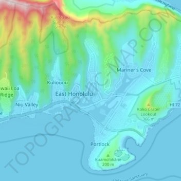
Name: Topografische Karte Hawaii Kai, Höhe, Relief.
Durchschnittliche Höhe: 113 m
Minimale Höhe: -6 m
Maximale Höhe: 755 m
Andere topografische Karten
Klicken Sie auf eine Karte, um ihre Topografie, ihre Höhe und ihr Relief anzuzeigen.
Diamond Head
United States > Hawaii > Honolulu County > Honolulu
Diamond Head, Honolulu, Honolulu County, Hawaii, 96186, United States
Durchschnittliche Höhe: 31 m
Hahaione Valley
United States > Hawaii > Honolulu County > Honolulu
Hahaione Valley, Honolulu, Honolulu County, Hawaii, United States
Durchschnittliche Höhe: 148 m
Diamond Head
United States > Hawaii > Honolulu County > Honolulu
Diamond Head, Honolulu, Honolulu County, Hawaii, 96815, United States
Durchschnittliche Höhe: 26 m
Ala Moana Beach
United States > Hawaii > Honolulu County > Honolulu
Ala Moana Beach, Ala Moana, Honolulu, Honolulu County, Hawaii, United States
Durchschnittliche Höhe: 4 m