
Topografische Karte Saint Paul
Interaktive Karte
Klicken Sie auf die Karte, um die Höhe anzuzeigen.
Über diese Karte
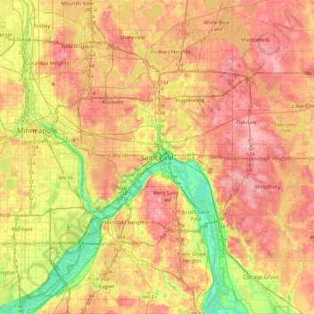
Name: Topografische Karte Saint Paul, Höhe, Relief.
Ort: Saint Paul, Ramsey County, Minnesota, 55101, United States (44.78975 -93.25310 45.10975 -92.93310)
Durchschnittliche Höhe: 273 m
Minimale Höhe: 199 m
Maximale Höhe: 335 m
The year 1858 saw more than 1,000 steamboats service Saint Paul, making it a gateway for settlers to the Minnesota frontier or Dakota Territory. Geography was a primary reason the city became a transportation hub. The location was the last good point to land riverboats coming upriver due to the river valley's topography. For a time, Saint Paul was called "The Last City of the East." Fort Snelling was important to St. Paul from the start. Direct access from St. Paul did not happen until the 7th bridge was built in 1880. Before that, there was a cable ferry crossing dating to at latest the 1840s. Once streetcars appeared, a new bridge to St. Paul was built in 1904. Until the town built its first jail the fort's brig served St. Paul.
Andere topografische Karten
Klicken Sie auf eine Karte, um ihre Topografie, ihre Höhe und ihr Relief anzuzeigen.
Southeast
United States > Minnesota > Ramsey County > Saint Paul
Southeast, Saint Paul, Ramsey County, Minnesota, United States
Durchschnittliche Höhe: 263 m
Highland Park
United States > Minnesota > Ramsey County > Saint Paul
Highland Park, Highland, Saint Paul, Ramsey County, Minnesota, United States
Durchschnittliche Höhe: 255 m
Summit Hill
United States > Minnesota > Ramsey County > Saint Paul
Summit Hill, Saint Paul, Ramsey County, Minnesota, United States
Durchschnittliche Höhe: 267 m
South Saint Anthony Park
United States > Minnesota > Ramsey County > Saint Paul
South Saint Anthony Park, Saint Anthony Park, Saint Paul, Ramsey County, Minnesota, United States
Durchschnittliche Höhe: 270 m