
Topografische Karte Osburn
Interaktive Karte
Klicken Sie auf die Karte, um die Höhe anzuzeigen.
Über diese Karte
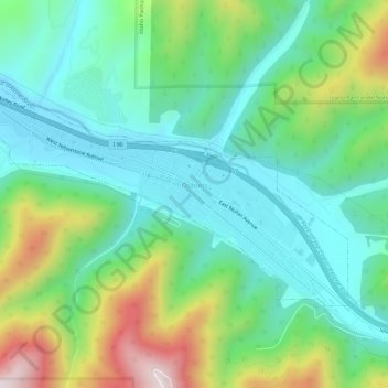
Name: Topografische Karte Osburn, Höhe, Relief.
Ort: Osburn, Shoshone County, Idaho, 83849, United States (47.49356 -116.03497 47.51662 -115.97591)
Durchschnittliche Höhe: 934 m
Minimale Höhe: 745 m
Maximale Höhe: 1.385 m
Osburn is located at 47°30′23″N 116°0′20″W / 47.50639°N 116.00556°W / 47.50639; -116.00556 (47.506464, -116.005535), at an elevation of 2,520 feet (768 m) above sea level.
Andere topografische Karten
Klicken Sie auf eine Karte, um ihre Topografie, ihre Höhe und ihr Relief anzuzeigen.
Devils Pulpit
United States > Idaho > Shoshone County
Devils Pulpit, Shoshone County, Idaho, United States
Durchschnittliche Höhe: 1.116 m
Canyon Peak
United States > Idaho > Shoshone County
Canyon Peak, Shoshone County, Idaho, United States
Durchschnittliche Höhe: 1.203 m
Pinehurst
United States > Idaho > Shoshone County
Pinehurst, Shoshone County, Idaho, 83850, United States
Durchschnittliche Höhe: 729 m
Kingston
United States > Idaho > Shoshone County
Kingston, Shoshone County, Idaho, 83839, United States
Durchschnittliche Höhe: 730 m
Wallace
United States > Idaho > Shoshone County
Wallace, Shoshone County, Idaho, 83873, United States
Durchschnittliche Höhe: 991 m
Pocono
United States > Idaho > Shoshone County
Pocono, Shoshone County, Idaho, United States
Durchschnittliche Höhe: 895 m
McDonalds
United States > Idaho > Shoshone County > McDonalds
McDonalds, Shoshone County, Idaho, United States
Durchschnittliche Höhe: 1.692 m
Kellogg
United States > Idaho > Shoshone County
Kellogg, Shoshone County, Idaho, 83837, United States
Durchschnittliche Höhe: 939 m
Mullan
United States > Idaho > Shoshone County
Mullan, Shoshone County, Idaho, 83846, United States
Durchschnittliche Höhe: 1.168 m
Clarkia
United States > Idaho > Shoshone County
Clarkia, Shoshone County, Idaho, 83812, United States
Durchschnittliche Höhe: 929 m