
Topografische Karte Dorchester
Interaktive Karte
Klicken Sie auf die Karte, um die Höhe anzuzeigen.
Über diese Karte
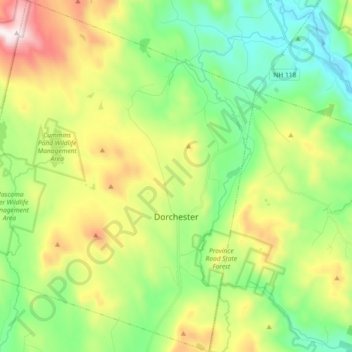
Name: Topografische Karte Dorchester, Höhe, Relief.
Ort: Dorchester, Grafton County, New Hampshire, United States (43.70581 -72.05818 43.83795 -71.90782)
Durchschnittliche Höhe: 439 m
Minimale Höhe: 153 m
Maximale Höhe: 979 m
According to the United States Census Bureau, the town has a total area of 45.2 square miles (117.1 km2), of which 44.6 square miles (115.5 km2) are land and 0.62 square miles (1.6 km2) are water, comprising 1.34% of the town. It is drained by the north-flowing South Branch Baker River and the south-flowing Mascoma River and its tributary, the Indian River. Cummins Pond and Reservoir Pond are in the west. The northeastern half of town which drains to the South Branch of the Baker is part of the Merrimack River watershed, while the southwestern half is part of the Connecticut River watershed. The highest point in Dorchester is on its western boundary, where the elevation reaches 3,190 feet (970 m) above sea level, just east of the summit of Smarts Mountain.
Andere topografische Karten
Klicken Sie auf eine Karte, um ihre Topografie, ihre Höhe und ihr Relief anzuzeigen.
East Hebron
United States > New Hampshire > Grafton County > Hebron
East Hebron, Hebron, Grafton County, New Hampshire, 03241, United States
Durchschnittliche Höhe: 268 m
Montcalm
United States > New Hampshire > Grafton County
Montcalm, Grafton County, New Hampshire, 03748, United States
Durchschnittliche Höhe: 436 m
Ashland
United States > New Hampshire > Grafton County
Ashland, Grafton County, New Hampshire, 03217, United States
Durchschnittliche Höhe: 231 m
Easton
United States > New Hampshire > Grafton County
Easton, Grafton County, New Hampshire, United States
Durchschnittliche Höhe: 586 m
Lyme Center
United States > New Hampshire > Grafton County > Lyme
Lyme Center, Lyme, Grafton County, New Hampshire, 03769, United States
Durchschnittliche Höhe: 336 m
Pike
United States > New Hampshire > Grafton County > Haverhill
Pike, Haverhill, Grafton County, New Hampshire, 03765, United States
Durchschnittliche Höhe: 287 m
Stinson Lake
United States > New Hampshire > Grafton County > Rumney > Stinson Lake
Stinson Lake, Rumney, Grafton County, New Hampshire, United States
Durchschnittliche Höhe: 460 m
West Lebanon
United States > New Hampshire > Grafton County > Lebanon
West Lebanon, Lebanon, Grafton County, New Hampshire, 03784, United States
Durchschnittliche Höhe: 165 m
Benton
United States > New Hampshire > Grafton County
Benton, Grafton County, New Hampshire, United States
Durchschnittliche Höhe: 558 m
Bridgewater
United States > New Hampshire > Grafton County
Bridgewater, Grafton County, New Hampshire, United States
Durchschnittliche Höhe: 302 m
Holderness
United States > New Hampshire > Grafton County
Holderness, Grafton County, New Hampshire, 03245, United States
Durchschnittliche Höhe: 252 m
Monroe
United States > New Hampshire > Grafton County
Monroe, Grafton County, New Hampshire, 03771, United States
Durchschnittliche Höhe: 320 m
North Woodstock
United States > New Hampshire > Grafton County > Woodstock
North Woodstock, Woodstock, Grafton County, New Hampshire, 03262, United States
Durchschnittliche Höhe: 306 m
Woodsville
United States > New Hampshire > Grafton County > Haverhill
Woodsville, Haverhill, Grafton County, New Hampshire, 05081, United States
Durchschnittliche Höhe: 195 m
Enfield Center
United States > New Hampshire > Grafton County > Enfield
Enfield Center, Enfield, Grafton County, New Hampshire, 03749, United States
Durchschnittliche Höhe: 357 m
Glencliff
United States > New Hampshire > Grafton County > Warren
Glencliff, Warren, Grafton County, New Hampshire, 03238, United States
Durchschnittliche Höhe: 410 m
Jewell Hill
United States > New Hampshire > Grafton County > Groton
Jewell Hill, Groton, Grafton County, New Hampshire, United States
Durchschnittliche Höhe: 466 m
Boutin Corner
United States > New Hampshire > Grafton County > Benton
Boutin Corner, Benton, Grafton County, New Hampshire, United States
Durchschnittliche Höhe: 446 m
Russel Pond
United States > New Hampshire > Grafton County > Woodstock
Russel Pond, Woodstock, Grafton County, New Hampshire, United States
Durchschnittliche Höhe: 513 m
Bristol
United States > New Hampshire > Grafton County
Bristol, Grafton County, New Hampshire, 03222, United States
Durchschnittliche Höhe: 254 m
Bethlehem
United States > New Hampshire > Grafton County
Bethlehem, Grafton County, New Hampshire, 03574, United States
Durchschnittliche Höhe: 528 m
Pine Knob
United States > New Hampshire > Grafton County > Bethlehem
Pine Knob, Bethlehem, Grafton County, New Hampshire, United States
Durchschnittliche Höhe: 413 m
Mount Pemigewasset
United States > New Hampshire > Grafton County > Lincoln
Mount Pemigewasset, Lincoln, Grafton County, New Hampshire, United States
Durchschnittliche Höhe: 608 m
Campton Lower Village
United States > New Hampshire > Grafton County > Campton
Campton Lower Village, Campton, Grafton County, New Hampshire, 03223, United States
Durchschnittliche Höhe: 260 m
Parker Hill
United States > New Hampshire > Grafton County > Lyman
Parker Hill, Lyman, Grafton County, New Hampshire, United States
Durchschnittliche Höhe: 350 m
Cheever
United States > New Hampshire > Grafton County > Dorchester
Cheever, Dorchester, Grafton County, New Hampshire, United States
Durchschnittliche Höhe: 330 m
Campton
United States > New Hampshire > Grafton County
Campton, Grafton County, New Hampshire, 03223, United States
Durchschnittliche Höhe: 336 m
Sugar Hill
United States > New Hampshire > Grafton County
Sugar Hill, Grafton County, New Hampshire, 03586, United States
Durchschnittliche Höhe: 372 m
Ashland Mill Dam
United States > New Hampshire > Grafton County > Ashland
Ashland Mill Dam, Ashland, Grafton County, New Hampshire, 03217, United States
Durchschnittliche Höhe: 204 m
Plymouth
United States > New Hampshire > Grafton County
Plymouth, Grafton County, New Hampshire, 03264, United States
Durchschnittliche Höhe: 264 m
Ellsworth
United States > New Hampshire > Grafton County
Ellsworth, Grafton County, New Hampshire, United States
Durchschnittliche Höhe: 444 m
Waterville Valley
United States > New Hampshire > Grafton County
Waterville Valley, Grafton County, New Hampshire, 03215, United States
Durchschnittliche Höhe: 649 m
Goose Pond
United States > New Hampshire > Grafton County > Canaan
Goose Pond, Canaan, Grafton County, New Hampshire, United States
Durchschnittliche Höhe: 318 m
Rumney
United States > New Hampshire > Grafton County
Rumney, Grafton County, New Hampshire, 03266, United States
Durchschnittliche Höhe: 389 m
Downing Mountain
United States > New Hampshire > Grafton County > Ellsworth
Downing Mountain, Ellsworth, Grafton County, New Hampshire, United States
Durchschnittliche Höhe: 445 m
Canaan
United States > New Hampshire > Grafton County
Canaan, Grafton County, New Hampshire, 03741, United States
Durchschnittliche Höhe: 404 m
Lyman
United States > New Hampshire > Grafton County
Lyman, Grafton County, New Hampshire, United States
Durchschnittliche Höhe: 347 m
Wentworth
United States > New Hampshire > Grafton County
Wentworth, Grafton County, New Hampshire, 03282, United States
Durchschnittliche Höhe: 422 m
Hebron
United States > New Hampshire > Grafton County
Hebron, Grafton County, New Hampshire, 03241, United States
Durchschnittliche Höhe: 327 m
Fairview
United States > New Hampshire > Grafton County > Woodstock
Fairview, Woodstock, Grafton County, New Hampshire, 03262, United States
Durchschnittliche Höhe: 365 m
Bath
United States > New Hampshire > Grafton County
Bath, Grafton County, New Hampshire, 03740, United States
Durchschnittliche Höhe: 289 m
Mountain Lakes
United States > New Hampshire > Grafton County > Haverhill
Mountain Lakes, Haverhill, Grafton County, New Hampshire, 03740, United States
Durchschnittliche Höhe: 281 m
Littleton
United States > New Hampshire > Grafton County
Littleton, Grafton County, New Hampshire, 03561, United States
Durchschnittliche Höhe: 360 m
Lonesome Lake
United States > New Hampshire > Grafton County > Lincoln
Lonesome Lake, Lincoln, Grafton County, New Hampshire, United States
Durchschnittliche Höhe: 810 m
Grafton
United States > New Hampshire > Grafton County
Grafton, Grafton County, New Hampshire, 03240, United States
Durchschnittliche Höhe: 409 m
Campton
United States > New Hampshire > Grafton County > Campton > Campton
Campton, Grafton County, New Hampshire, 03223, United States
Durchschnittliche Höhe: 255 m
Haverhill
United States > New Hampshire > Grafton County
Haverhill, Grafton County, New Hampshire, United States
Durchschnittliche Höhe: 267 m
Woodstock
United States > New Hampshire > Grafton County > Woodstock > Woodstock
Woodstock, Grafton County, New Hampshire, 03262, United States
Durchschnittliche Höhe: 333 m
Orange
United States > New Hampshire > Grafton County
Orange, Grafton County, New Hampshire, United States
Durchschnittliche Höhe: 457 m
Meadow Brook
United States > New Hampshire > Grafton County
Meadow Brook, Livermore, Grafton County, New Hampshire, United States
Durchschnittliche Höhe: 568 m