
Topografische Karte White County
Interaktive Karte
Klicken Sie auf die Karte, um die Höhe anzuzeigen.
Über diese Karte
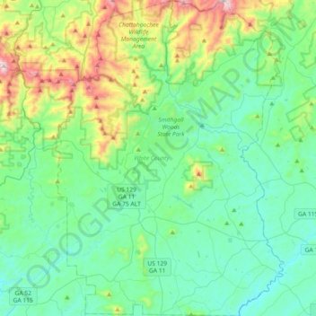
Name: Topografische Karte White County, Höhe, Relief.
Ort: White County, Georgia, United States (34.50359 -83.87735 34.80137 -83.61559)
Durchschnittliche Höhe: 556 m
Minimale Höhe: 337 m
Maximale Höhe: 1.333 m
The county is mostly located in the foothills of the Blue Ridge Mountains. Northern parts of the county have the highest elevations, being in the mountains themselves. The highest point in White County is 4,430-foot (1,350 m) Tray Mountain, shared with Towns County to the north. Tray Mountain is the 6th-highest mountain in Georgia. Another very prominent White County peak is Yonah Mountain, also known as Mount Yonah. This 3,143-foot (958 m) peak, located between Helen and Cleveland, is rimmed by sheer cliffs and is the highest point on Georgia's Piedmont Plateau.
Andere topografische Karten
Klicken Sie auf eine Karte, um ihre Topografie, ihre Höhe und ihr Relief anzuzeigen.
Atlanta
United States > Georgia > Fulton County
Atlanta, Fulton County, Georgia, United States
Durchschnittliche Höhe: 284 m
Savannah
United States > Georgia > Chatham County
Savannah, Chatham County, Georgia, United States
Durchschnittliche Höhe: 4 m
Dahlonega
United States > Georgia > Lumpkin County
Dahlonega, Lumpkin County, Georgia, United States
Durchschnittliche Höhe: 411 m
Augusta
United States > Georgia > Augusta
Augusta, Richmond County, Georgia, 30901, United States
Durchschnittliche Höhe: 90 m
Athens
United States > Georgia > Athens
Athens, Athens-Clarke County, Georgia, 303341458, United States
Durchschnittliche Höhe: 221 m
Camden County
Camden County, Georgia, United States
Durchschnittliche Höhe: 4 m
Georgia International Horse Park
United States > Georgia > Rockdale County > Conyers
Georgia International Horse Park, Conyers, Rockdale County, Georgia, United States
Durchschnittliche Höhe: 209 m
Helen
United States > Georgia > White County
Helen, White County, Georgia, 30545, United States
Durchschnittliche Höhe: 488 m
Blue Ridge
United States > Georgia > Fannin County
Blue Ridge, Fannin County, Georgia, United States
Durchschnittliche Höhe: 535 m
Gwinnett County
Gwinnett County, Georgia, United States
Durchschnittliche Höhe: 302 m
Ellijay
United States > Georgia > Gilmer County
Ellijay, Gilmer County, Georgia, 30540, United States
Durchschnittliche Höhe: 424 m
Tybee Island
United States > Georgia > Chatham County
Tybee Island, Chatham County, Georgia, 31328, United States
Durchschnittliche Höhe: 1 m
Saint Simons Island
United States > Georgia > Glynn County
Saint Simons Island, Glynn County, Georgia, 31561, United States
Durchschnittliche Höhe: 2 m
Macon
United States > Georgia > Bibb County
Macon, Bibb County, Georgia, United States
Durchschnittliche Höhe: 127 m
Atlanta
United States > Georgia > Fulton County
Atlanta, Fulton County, Georgia, 30303, United States
Durchschnittliche Höhe: 285 m
Union County
Union County, Georgia, United States
Durchschnittliche Höhe: 716 m
Alpharetta
United States > Georgia > Fulton County
Alpharetta, Fulton County, Georgia, United States
Durchschnittliche Höhe: 324 m
Blairsville
United States > Georgia > Union County
Blairsville, Union County, Georgia, United States
Durchschnittliche Höhe: 587 m
Columbus
United States > Georgia > Muscogee County
Columbus, Muscogee County, Georgia, United States
Durchschnittliche Höhe: 130 m
Carroll County
Carroll County, Georgia, United States
Durchschnittliche Höhe: 325 m
Vinings
United States > Georgia > Cobb County
Vinings, Cobb County, Georgia, 30339, United States
Durchschnittliche Höhe: 281 m
Hiawassee
United States > Georgia > Towns County
Hiawassee, Towns County, Georgia, United States
Durchschnittliche Höhe: 620 m
Rabun County
Rabun County, Georgia, United States
Durchschnittliche Höhe: 687 m
Skidaway Island
United States > Georgia > Chatham County
Skidaway Island, Chatham County, Georgia, 31411, United States
Durchschnittliche Höhe: 3 m
Brunswick
United States > Georgia > Glynn County
Brunswick, Glynn County, Georgia, United States
Durchschnittliche Höhe: 2 m
Floyd County
Floyd County, Georgia, United States
Durchschnittliche Höhe: 238 m
Fannin County
Fannin County, Georgia, United States
Durchschnittliche Höhe: 628 m
Lumpkin
United States > Georgia > Stewart County
Lumpkin, Stewart County, Georgia, United States
Durchschnittliche Höhe: 147 m
Alapaha River
Alapaha River, Georgia, United States
Durchschnittliche Höhe: 65 m
DeKalb County
DeKalb County, Georgia, United States
Durchschnittliche Höhe: 284 m
Gainesville
United States > Georgia > Hall County
Gainesville, Hall County, Georgia, 30501, United States
Durchschnittliche Höhe: 346 m
Canton
United States > Georgia > Cherokee County
Canton, Cherokee County, Georgia, United States
Durchschnittliche Höhe: 320 m
Jointer Island
United States > Georgia > Glynn County > Brunswick
Jointer Island, Brunswick, Glynn County, Georgia, United States
Durchschnittliche Höhe: 0 m
Heritage Acres
United States > Georgia > Bibb County > Macon
Heritage Acres, Macon, Bibb County, Georgia, 31211, United States
Durchschnittliche Höhe: 119 m
Robins Air Force Base
United States > Georgia > Houston County
Robins Air Force Base, Houston County, Georgia, 31098, United States
Durchschnittliche Höhe: 92 m
Stone Mountain
United States > Georgia > DeKalb County
Stone Mountain, DeKalb County, Georgia, 30087, United States
Durchschnittliche Höhe: 299 m
Woodstock
United States > Georgia > Cherokee County
Woodstock, Cherokee County, Georgia, United States
Durchschnittliche Höhe: 296 m
Mountain City
United States > Georgia > Rabun County
Mountain City, Rabun County, Georgia, 30562, United States
Durchschnittliche Höhe: 747 m
Forsyth County
Forsyth County, Georgia, United States
Durchschnittliche Höhe: 344 m
Lake Oconee
United States > Georgia > Greene County > Lake Oconee
Lake Oconee, Greene County, Georgia, United States
Durchschnittliche Höhe: 165 m
Kennesaw
United States > Georgia > Cobb County
Kennesaw, Cobb County, Georgia, 30144, United States
Durchschnittliche Höhe: 317 m
Iron Mountain
United States > Georgia > Murray County
Iron Mountain, Murray County, Georgia, United States
Durchschnittliche Höhe: 362 m
Fort Pulaski
United States > Georgia > Chatham County
Fort Pulaski, Fort Perimeter Trail, Chatham County, Georgia, 31328, United States
Durchschnittliche Höhe: 1 m
Tugaloo
United States > Georgia > Habersham County > Tallulah Falls
Tugaloo, Tallulah Falls, Habersham County, Georgia, United States
Durchschnittliche Höhe: 392 m
Elmodel
United States > Georgia > Baker County
Elmodel, Baker County, Georgia, United States
Durchschnittliche Höhe: 51 m
Leary
United States > Georgia > Calhoun County
Leary, Calhoun County, Georgia, 39862, United States
Durchschnittliche Höhe: 61 m
Fargo
United States > Georgia > Clinch County
Fargo, Clinch County, Georgia, United States
Durchschnittliche Höhe: 34 m
Worley Crossroads
United States > Georgia > Cherokee County
Worley Crossroads, Cherokee County, Georgia, United States
Durchschnittliche Höhe: 378 m
Fernwood
United States > Georgia > Fayette County > Peachtree City
Fernwood, Peachtree City, Fayette County, Georgia, 30269, United States
Durchschnittliche Höhe: 261 m