Geolokalisieren

Topografische Karte Briouze

Interaktive Karte

Klicken Sie auf die Karte, um die Höhe anzuzeigen.

Über diese Karte

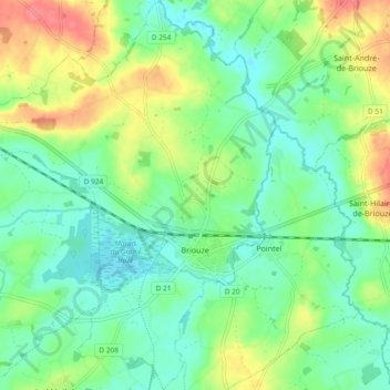
Name: Topografische Karte Briouze, Höhe, Relief.

Ort: Briouze, Argentan, Orne, Normandie, France métropolitaine, 61220, France (48.67745 -0.42296 48.73911 -0.34764)

Durchschnittliche Höhe: 220 m

Minimale Höhe: 197 m

Maximale Höhe: 264 m

Andere topografische Karten

Klicken Sie auf eine Karte, um ihre Topografie, ihre Höhe und ihr Relief anzuzeigen.

Le frene

France > Normandie > Orne > Domfront en Poiraie > Domfront

Le frene, Domfront, Domfront en Poiraie, Argentan, Orne, Normandie, France métropolitaine, 61700, France

Durchschnittliche Höhe: 195 m

Saint-Germain-du-Corbéis

France > Normandie > Orne

Saint-Germain-du-Corbéis, Alençon, Orne, Normandie, France métropolitaine, 61000, France

Durchschnittliche Höhe: 152 m

Montreuil-au-Houlme

France > Normandie > Orne

Montreuil-au-Houlme, Argentan, Orne, Normandie, France métropolitaine, 61210, France

Durchschnittliche Höhe: 223 m

Gacé

France > Normandie > Orne

Gacé, Mortagne-au-Perche, Orne, Normandie, France métropolitaine, 61230, France

Durchschnittliche Höhe: 227 m

Macé

France > Normandie > Orne > Macé

Macé, Alençon, Orne, Normandie, France métropolitaine, 61500, France

Durchschnittliche Höhe: 182 m

Lignères

France > Normandie > Orne

Lignères, Mortagne-au-Perche, Orne, Normandie, France métropolitaine, 61240, France

Durchschnittliche Höhe: 247 m

Ceton

France > Normandie > Orne

Ceton, Mortagne-au-Perche, Orne, Normandie, France métropolitaine, 61260, France

Durchschnittliche Höhe: 161 m