
Topografische Karte Tryon
Interaktive Karte
Klicken Sie auf die Karte, um die Höhe anzuzeigen.
Über diese Karte
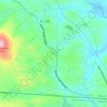
Name: Topografische Karte Tryon, Höhe, Relief.
Ort: Tryon, Polk County, North Carolina, United States (35.19654 -82.25175 35.21942 -82.22512)
Durchschnittliche Höhe: 333 m
Minimale Höhe: 272 m
Maximale Höhe: 498 m
The elevation of the town is 1,067 feet (325 m) above sea level. The town's original boundary was established as a circle with a radius of three quarters of a mile. According to the United States Census Bureau, the town has a total area of 1.8 square miles (4.7 km2), all land.
Andere topografische Karten
Klicken Sie auf eine Karte, um ihre Topografie, ihre Höhe und ihr Relief anzuzeigen.
Hickory Grove
United States > North Carolina > Polk County
Hickory Grove, Polk County, North Carolina, United States
Durchschnittliche Höhe: 281 m
Mill Spring
United States > North Carolina > Polk County
Mill Spring, Polk County, North Carolina, 28756, United States
Durchschnittliche Höhe: 318 m
Green River
United States > North Carolina > Polk County
Green River, Polk County, North Carolina, 28756, United States
Durchschnittliche Höhe: 538 m
Lake Adger
United States > North Carolina > Polk County
Lake Adger, Polk County, North Carolina, United States
Durchschnittliche Höhe: 312 m
Melrose
United States > North Carolina > Polk County > Melrose
Melrose, Polk County, North Carolina, 28773, United States
Durchschnittliche Höhe: 610 m
Saluda
United States > North Carolina > Polk County
Saluda, Polk County, North Carolina, 28773, United States
Durchschnittliche Höhe: 635 m
Green Creek
United States > North Carolina > Polk County > Green Creek
Green Creek, Polk County, North Carolina, United States
Durchschnittliche Höhe: 290 m