
Topografische Karte Meigs County
Interaktive Karte
Klicken Sie auf die Karte, um die Höhe anzuzeigen.
Über diese Karte
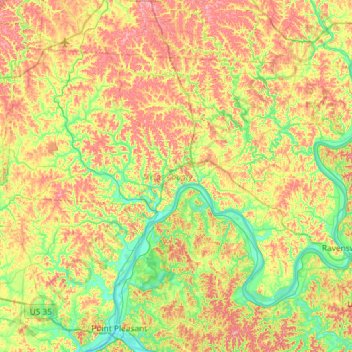
Name: Topografische Karte Meigs County, Höhe, Relief.
Ort: Meigs County, Ohio, United States (38.87387 -82.32413 39.20549 -81.74219)
Durchschnittliche Höhe: 226 m
Minimale Höhe: 166 m
Maximale Höhe: 310 m
Meigs County lies in the Appalachian Plateau physiographic region of the Appalachian Mountains. The landscape is considered to be anywhere from gently rolling to rugged, typical of a dissected plateau. Elevations range from 1,020 feet (310 m) asl (above sea level) in the southwest to about 535 feet (163 m) asl in the far south central part of the county along the Ohio River. The majority of Meigs County is drained by two subwatersheds of the Ohio River, Shade River and Leading Creek. Another stream of note is Raccoon Creek, which flows through a small area of the northwestern corner of the county.
Andere topografische Karten
Klicken Sie auf eine Karte, um ihre Topografie, ihre Höhe und ihr Relief anzuzeigen.
Cincinnati
United States > Ohio > Hamilton County
Cincinnati, Hamilton County, Ohio, United States
Durchschnittliche Höhe: 222 m
Columbus
United States > Ohio > Franklin County
Columbus, Franklin County, Ohio, United States
Durchschnittliche Höhe: 261 m
Dayton
United States > Ohio > Montgomery County
Dayton, Montgomery County, Ohio, United States
Durchschnittliche Höhe: 270 m
Cleveland
United States > Ohio > Cuyahoga County
Cleveland, Cuyahoga County, Ohio, United States
Durchschnittliche Höhe: 215 m
Marietta
United States > Ohio > Washington County
Marietta, Washington County, Ohio, 45750, United States
Durchschnittliche Höhe: 215 m
Akron
United States > Ohio > Summit County
Akron, Summit County, Ohio, United States
Durchschnittliche Höhe: 315 m
Columbiana County
Columbiana County, Ohio, United States
Durchschnittliche Höhe: 347 m
Clermont County
Clermont County, Ohio, United States
Durchschnittliche Höhe: 247 m
Peninsula
United States > Ohio > Summit County
Peninsula, Summit County, Ohio, United States
Durchschnittliche Höhe: 259 m
Commercial Point
United States > Ohio > Pickaway County
Commercial Point, Pickaway County, Ohio, United States
Durchschnittliche Höhe: 238 m
Hocking Hills State Park
United States > Ohio > Hocking County
Hocking Hills State Park, Hocking County, Ohio, United States
Durchschnittliche Höhe: 292 m
Richland County
Richland County, Ohio, United States
Durchschnittliche Höhe: 362 m
Franklin County
Franklin County, Ohio, United States
Durchschnittliche Höhe: 262 m
Hamilton County
Hamilton County, Ohio, United States
Durchschnittliche Höhe: 221 m
Kent
United States > Ohio > Portage County
Kent, Portage County, Ohio, United States
Durchschnittliche Höhe: 328 m
Jewett
United States > Ohio > Harrison County
Jewett, Harrison County, Ohio, United States
Durchschnittliche Höhe: 340 m
Richmond
United States > Ohio > Jefferson County
Richmond, Jefferson County, Ohio, 43944, United States
Durchschnittliche Höhe: 364 m
Delaware County
Delaware County, Ohio, United States
Durchschnittliche Höhe: 302 m
Ashtabula County
Ashtabula County, Ohio, United States
Durchschnittliche Höhe: 237 m
New Athens
United States > Ohio > Harrison County
New Athens, Harrison County, Ohio, 43981, United States
Durchschnittliche Höhe: 359 m
Bevis
United States > Ohio > Hamilton County
Bevis, Colerain Township, Hamilton County, Ohio, 45251, United States
Durchschnittliche Höhe: 265 m
Russell Township
United States > Ohio > Geauga County
Russell Township, Geauga County, Ohio, United States
Durchschnittliche Höhe: 334 m
Yelverton
United States > Ohio > Hardin County
Yelverton, Taylor Creek Township, Hardin County, Ohio, United States
Durchschnittliche Höhe: 329 m
Jump
United States > Ohio > Hardin County
Jump, McDonald Township, Hardin County, Ohio, United States
Durchschnittliche Höhe: 303 m
Beavercreek
United States > Ohio > Greene County
Beavercreek, Greene County, Ohio, United States
Durchschnittliche Höhe: 274 m
Cuyahoga County
Cuyahoga County, Ohio, United States
Durchschnittliche Höhe: 211 m
Canton
United States > Ohio > Stark County
Canton, Stark County, Ohio, United States
Durchschnittliche Höhe: 335 m
Findlay
United States > Ohio > Hancock County
Findlay, Hancock County, Ohio, United States
Durchschnittliche Höhe: 243 m
Richard and Lucile Durrell Edge of Appalachia Preserve
United States > Ohio > Adams County
Richard and Lucile Durrell Edge of Appalachia Preserve, Adams County, Ohio, 45650, United States
Durchschnittliche Höhe: 222 m
Pfeiffer
United States > Ohio > Hardin County
Pfeiffer, Dudley Township, Hardin County, Ohio, United States
Durchschnittliche Höhe: 294 m
Portage County
Deerfield Township, Portage County, Ohio, United States
Durchschnittliche Höhe: 320 m
New California
United States > Ohio > Union County
New California, Jerome Township, Union County, Ohio, United States
Durchschnittliche Höhe: 299 m
Smyrna
United States > Ohio > Harrison County
Smyrna, Harrison County, Ohio, 43973, United States
Durchschnittliche Höhe: 329 m
Tinkers Creek State Park
United States > Ohio > Portage County > Aurora
Tinkers Creek State Park, Aurora, Portage County, Ohio, United States
Durchschnittliche Höhe: 314 m
Springfield
United States > Ohio > Clark County
Springfield, Clark County, Ohio, United States
Durchschnittliche Höhe: 310 m
New Rumley
United States > Ohio > Harrison County
New Rumley, Harrison County, Ohio, 43986, United States
Durchschnittliche Höhe: 349 m
Alger
United States > Ohio > Hardin County
Alger, Marion Township, Hardin County, Ohio, United States
Durchschnittliche Höhe: 304 m
Westfield
United States > Ohio > Morrow County
Westfield, Westfield Township, Morrow County, Ohio, 43003, United States
Durchschnittliche Höhe: 295 m
Tappan
United States > Ohio > Harrison County
Tappan, Harrison County, Ohio, United States
Durchschnittliche Höhe: 305 m