
Topografische Karte Ashley National Forest
Interaktive Karte
Klicken Sie auf die Karte, um die Höhe anzuzeigen.
Über diese Karte
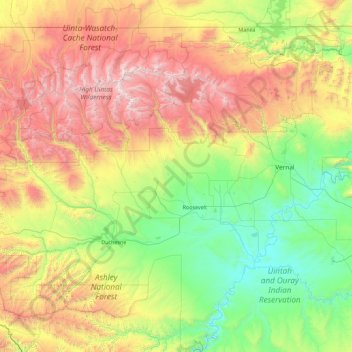
Name: Topografische Karte Ashley National Forest, Höhe, Relief.
Ort: Ashley National Forest, Utah, United States of America (39.86976 -111.03895 40.96517 -109.24133)
Durchschnittliche Höhe: 2.248 m
Minimale Höhe: 1.405 m
Maximale Höhe: 4.088 m
Andere topografische Karten
Klicken Sie auf eine Karte, um ihre Topografie, ihre Höhe und ihr Relief anzuzeigen.
Jackson Hole
United States of America > Utah
Jackson Hole, Grand County, Utah, United States of America
Durchschnittliche Höhe: 1.313 m
Wasatch Range
United States of America > Utah > Sandy
Wasatch Range, Sandy, Salt Lake County, Utah, United States of America
Durchschnittliche Höhe: 1.880 m
Hyrum
United States of America > Utah > Hyrum
Hyrum, Cache County, Utah, United States of America
Durchschnittliche Höhe: 1.442 m
Mount Nebo
United States of America > Utah
Mount Nebo, Juab County, Utah, United States of America
Durchschnittliche Höhe: 3.115 m
Towne Center Apartments
United States of America > Utah > Herriman > Towne Center Apartments
Towne Center Apartments, Herriman, Salt Lake County, Utah, 84096, United States of America
Durchschnittliche Höhe: 1.467 m
Moon Apartments
United States of America > Utah > Provo > Moon Apartments
Moon Apartments, Provo, Utah County, Utah, 84601, United States of America
Durchschnittliche Höhe: 1.421 m
(West) Mueller Park
United States of America > Utah > Bountiful
(West) Mueller Park, Bountiful, Davis County, Utah, United States of America
Durchschnittliche Höhe: 1.473 m
Linden Circle
United States of America > Utah > Holladay
Linden Circle, Holladay, Salt Lake County, Utah, 85412, United States of America
Durchschnittliche Höhe: 1.365 m
Eddie Kay
United States of America > Utah > Millcreek
Eddie Kay, Millcreek, Salt Lake County, Utah, 84117, United States of America
Durchschnittliche Höhe: 1.331 m
Wendover
United States of America > Utah > Wendover
Wendover, Tooele County, Utah, 84083, United States of America
Durchschnittliche Höhe: 1.369 m
Salt Point
United States of America > Utah
Salt Point, Emery County, Utah, United States of America
Durchschnittliche Höhe: 1.811 m
Twin Peaks
United States of America > Utah > Midvale
Twin Peaks, Midvale, Salt Lake County, Utah, 84107, United States of America
Durchschnittliche Höhe: 1.337 m