
Topografische Karte Banff-Nationalpark
Interaktive Karte
Klicken Sie auf die Karte, um die Höhe anzuzeigen.
Über diese Karte
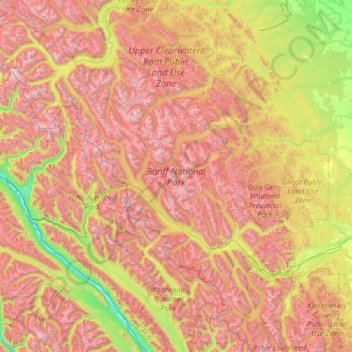
Name: Topografische Karte Banff-Nationalpark, Höhe, Relief.
Ort: Banff-Nationalpark, Alberta, Kanada (50.70506 -117.31712 52.27145 -115.16491)
Durchschnittliche Höhe: 1.848 m
Minimale Höhe: 773 m
Maximale Höhe: 3.472 m
Andere topografische Karten
Klicken Sie auf eine Karte, um ihre Topografie, ihre Höhe und ihr Relief anzuzeigen.
Lake Louise
Kanada > Alberta > Improvement District No. 9
Lake Louise ist in drei Ortsteile gegliedert. Der Hauptort, der als The Village of Lake Louise bezeichnet wird, liegt auf einer niedrigen Höhe im Talgrund. Das östlich gelegene Skigebiet Lake Louise Mountain Resort gruppiert sich mit mehreren Gondelbahnen und Sesselliften hauptsächlich am Mount Richardson…
Durchschnittliche Höhe: 1.617 m
Victoria Ridge
Kanada > Alberta > Municipal District of Pincher Creek No. 9
Durchschnittliche Höhe: 2.194 m