
Topografische Karte Derry/Londonderry
Interaktive Karte
Klicken Sie auf die Karte, um die Höhe anzuzeigen.
Derry/Londonderry
Der Umfang von 6 Meter liegt an der oberen Grenze der bekannten Größen für Rundtürme, widerspricht damit aber keineswegs der Annahme, dass es sich hierbei um den originären Rundturm handelt. Auch die höher gelegene Türöffnung ist für Rundtürme typisch.
Über diese Karte
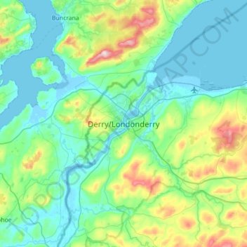
Name: Topografische Karte Derry/Londonderry, Höhe, Relief.
Durchschnittliche Höhe: 88 m
Minimale Höhe: -5 m
Maximale Höhe: 478 m