
Topografische Karte Saragossa
Interaktive Karte
Klicken Sie auf die Karte, um die Höhe anzuzeigen.
Saragossa
Die Großstadt Saragossa liegt an der Einmündung des Río Huerva in den Ebro auf rund 240 m Höhe. Das Klima ist gemäßigt bis warm; Regen (ca. 355 mm/Jahr) fällt übers Jahr verteilt.
Über diese Karte
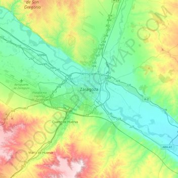
Name: Topografische Karte Saragossa, Höhe, Relief.
Ort: Saragossa, Zaragoza, Saragossa, Aragonien, 50001, Spanien (41.49213 -1.04094 41.81213 -0.72094)
Durchschnittliche Höhe: 310 m
Minimale Höhe: 169 m
Maximale Höhe: 646 m