
Spenden
Rüste dich für dein nächstes Abenteuer:
Als Amazon-Partner verdient diese Website an qualifizierten Käufen, ohne zusätzliche Kosten für Sie.
Topografische Karte Boulder
Klicken Sie auf die Karte, um die Höhe anzuzeigen.
Spenden
Rüste dich für dein nächstes Abenteuer:
Als Amazon-Partner verdient diese Website an qualifizierten Käufen, ohne zusätzliche Kosten für Sie.
Boulder
Die Stadt bemühte ab dieser Zeit einerseits um die Schaffung neuer Jobs für die gewachsene Einwohnerschaft und andererseits um einen Erhalt der Lebensqualität und natürlichen Umgebung. So wurde vor allem um Unternehmen aus der Cleantech-Branche geworben. Im Jahr 1952 eröffnete das National Bureau of Standards eine Außenstelle in Boulder. Andere Einrichtungen und Unternehmen mit dem Schwerpunkt Forschung und Entwicklung folgten. Zu dieser Zeit stieß gleichfalls der U.S. Highway 36 nach Boulder vor, so dass nun eine Anbindung per Schnellstraße nach Denver bestand. Im Sinne des Naturschutzes beschloss die Stadt 1959, dass sie eine Wasserversorgung nur bis zu einer Höhe von 1750 m über dem Meeresspiegel zur Verfügung stellte. So sollten die höher liegende Flächen in den Bergen vor einer Besiedelung geschützt werden. 1961 sprachen sich die Bürger in einem Referendum für die Bildung des Boulder Parks and Recreation Departments aus, einer Behörde, die die bereits bestehenden Parks und Naherholungsgebiete in eine Verwaltungseinheit integrierte. Mit dem Bevölkerungswachstum, das 1972 zu einer Einwohnerzahl von 72.000 führte, ging der Bau neuer Wohn- und Gewerbegebiete wie Highland Park-Martin Acres und Balsam North sowie mit North Broadway und Basemar der ersten zwei Einkaufszentren einher. Zusätzlich wurden von der Stadt ab 1967 Baulücken aufgekauft, um die Besiedelung zu verdichten, und Bausubstanz aus der Vergangenheit umfunktioniert. Im Jahr 1972 erging ein Gesetz, das die maximale Gebäudehöhe festlegte. Im September 1974 folgte eines zum Denkmalschutz, um historisch bedeutsame Bauten zu bewahren.
Spenden
Rüste dich für dein nächstes Abenteuer:
Als Amazon-Partner verdient diese Website an qualifizierten Käufen, ohne zusätzliche Kosten für Sie.
Über diese Karte
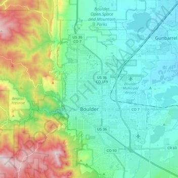
Name: Topografische Karte Boulder, Höhe, Relief.
Durchschnittliche Höhe: 1.800 m
Minimale Höhe: 1.557 m
Maximale Höhe: 2.545 m
Spenden
Rüste dich für dein nächstes Abenteuer:
Als Amazon-Partner verdient diese Website an qualifizierten Käufen, ohne zusätzliche Kosten für Sie.
Andere topografische Karten
Klicken Sie auf eine Karte, um ihre Topografie, ihre Höhe und ihr Relief anzuzeigen.
The Flatirons
Vereinigte Staaten von Amerika > Colorado > Boulder County
Durchschnittliche Höhe: 2.051 m
Boulder
Vereinigte Staaten von Amerika > Colorado > Boulder County > Boulder
Durchschnittliche Höhe: 1.977 m