
Spenden
Rüste dich für dein nächstes Abenteuer:
Als Amazon-Partner verdient diese Website an qualifizierten Käufen, ohne zusätzliche Kosten für Sie.
Topografische Karte Coniston Water
Klicken Sie auf die Karte, um die Höhe anzuzeigen.
Spenden
Rüste dich für dein nächstes Abenteuer:
Als Amazon-Partner verdient diese Website an qualifizierten Käufen, ohne zusätzliche Kosten für Sie.
Coniston Water
Coniston Water ist der drittgrößte See im englischen Lake District. Er ist 8 km lang und 800 m breit bei einer maximalen Tiefe von 56 m und einer Fläche von 4,9 km². Er liegt auf einer Höhe von 44 m über dem Meeresspiegel. Am nördlichen Ende liegt der Ort Coniston. Seine Zuflüsse nahe dem Ort Coniston sind der Yewdale Beck und der Church Beck und die südlich davon gelegenen Torver Beck und Selside Beck. Sein Abfluss nach Süden ist der River Crake.
Spenden
Rüste dich für dein nächstes Abenteuer:
Als Amazon-Partner verdient diese Website an qualifizierten Käufen, ohne zusätzliche Kosten für Sie.
Über diese Karte
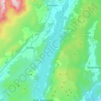
Name: Topografische Karte Coniston Water, Höhe, Relief.
Durchschnittliche Höhe: 186 m
Minimale Höhe: 17 m
Maximale Höhe: 791 m
Spenden
Rüste dich für dein nächstes Abenteuer:
Als Amazon-Partner verdient diese Website an qualifizierten Käufen, ohne zusätzliche Kosten für Sie.