
Topografische Karte Tupiza
Interaktive Karte
Klicken Sie auf die Karte, um die Höhe anzuzeigen.
Tupiza
Tupiza ist die Hauptstadt der Provinz Sur Chichas und der zentrale Ort im Cantón Tupiza und im Municipio Tupiza. Die Stadt liegt auf einer Höhe von 2965 m im Tal des Río Tupiza, einem der Quellflüsse des Río Pilcomayo.
Über diese Karte
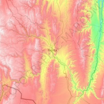
Name: Topografische Karte Tupiza, Höhe, Relief.
Ort: Tupiza, Sur Chichas, Potosí, Bolivien (-21.85991 -66.33675 -21.06841 -65.24457)
Durchschnittliche Höhe: 3.555 m
Minimale Höhe: 2.239 m
Maximale Höhe: 4.686 m