
Topografische Karte Ladakh
Klicken Sie auf die Karte, um die Höhe anzuzeigen.
Ladakh
Ladakh erstreckt sich zwischen den Gebirgsketten des Himalaya (mit dem Stok Kangri als bekanntestem Berg) und des Karakorum und dem oberen Tal des Indus. Die Täler befinden sich auf einer Höhe von 3000 m ü. d. M., womit sie die höchstliegenden Kaschmirs sind. Die Berge erreichen Höhen von über 7000 m ü. d. M. Der 1913 erstmals bestiegene Nun mit 7135 m und der benachbarte Kun mit 7077 m, der 1906 erstmals bezwungen werden konnte, sind die höchsten Berge Ladakhs. Die Hauptstadt von Ladakh ist Leh (etwa 27.500 Einwohner). Unweit von Leh befindet sich der Khardong-Pass, einer der höchsten befahrbaren Pässe der Welt.
Über diese Karte
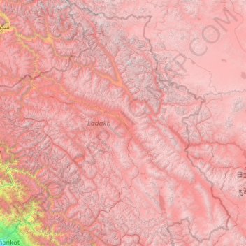
Name: Topografische Karte Ladakh, Höhe, Relief.
Ort: Ladakh, Indien (32.33574 75.32697 35.67455 79.46075)
Durchschnittliche Höhe: 4.726 m
Minimale Höhe: 337 m
Maximale Höhe: 7.470 m
Andere topografische Karten
Klicken Sie auf eine Karte, um ihre Topografie, ihre Höhe und ihr Relief anzuzeigen.
Nashik
Indien > Maharashtra > Nashik Subdistrict
Nashik liegt im Norden der Westghats am heiligen Fluss Godavari in einer Höhe von etwa 570 m. Die Stadt Mumbai befindet sich etwa 165 km (Fahrtstrecke) südwestlich; die indische Hauptstadt Delhi liegt etwa 1250 km nordöstlich. Das Klima ist warm; Regen (ca. 810 mm/Jahr) fällt hauptsächlich während der…
Durchschnittliche Höhe: 631 m
Rishikesh
Indien > Uttarakhand > Rishikesh
Rishikesh hat ungefähr 70.000 Einwohner und liegt in einer Höhe von 372 m. Von Delhi ist sie 225 km entfernt, von der bedeutenden Pilgerstadt Haridwar 24 km.
Durchschnittliche Höhe: 497 m
Mysuru
Indien > Karnataka > Mysuru taluk
Mysuru liegt etwa 155 km (Fahrtstrecke) südwestlich von Bengaluru im südlichen Dekkan-Hochland in einer Höhe von ca. 770 m ü. d. M.
Durchschnittliche Höhe: 727 m
Mumbai
1950 wurden die nahen und 1957 die weiter entfernt liegenden Vororte eingemeindet. Dadurch erhöhte sich die Einwohnerzahl weiter. Von 1911 bis 1991 verzehnfachte sich diese nochmals; in der eigentlichen Stadt ohne Vorortgürtel lebten 9,9 Millionen Menschen, im Jahr 2011 waren es 12,5 Millionen. Die…
Durchschnittliche Höhe: 13 m
Leh
Die Wasserversorgung für die Landwirtschaft von Leh basiert überwiegend auf Schmelzwasser der Gletscher aus dem östlich gelegenen Gebiet des Khardung-La und der westlichen, höhergelegenen Schneefelder. Für Trinkwasser werden ausschließlich Quell- und Grundwasser genutzt. Dieses wird aus privaten Brunnen,…
Durchschnittliche Höhe: 3.653 m
Dharamsala
Indien > Himachal Pradesh > Dharamshala
Dharamsala ist aufgeteilt in das wirtschaftliche Zentrum Lower Dharamsala (auch Kotwali Bazaar u. a., 1280 m) und das ca. 5 km (Luftlinie), aber ca. 15 km Fahrtstrecke nördlich gelegene Pilgerzentrum Upper Dharamsala (auch McLeod Ganj, 1830 m). Aufgrund der Höhendifferenz liegen beide Ortsteile getrennt.…
Durchschnittliche Höhe: 1.781 m
Kangchendzönga
Indien > Sikkim > Chungthang
Bis 1852 glaubte man, der Kangchendzönga sei der höchste Berg der Erde. Erst die Berechnungen der trigonometrischen Vermessung Indiens durch die Briten 1849 bewiesen, dass Mount Everest und K2 noch höher sind und der Kangchendzönga damit der dritthöchste Berg der Erde ist.
Durchschnittliche Höhe: 7.725 m
Srinagar
Indien > Jammu und Kaschmir > Srinagar (South)
Die Stadt hat etwa 1,2 Millionen Einwohner (Volkszählung 2011). Srinagar befindet sich auf einer Höhe von 1730 m über dem Meeresspiegel zentral im Hochbecken von Kaschmir, am Fluss Jhelam, der das gesamte Becken entwässert.
Durchschnittliche Höhe: 1.805 m
Mayapur
Indien > Westbengalen > Nabadwip
Mayapur liegt im Mündungsdreieck zwischen Jalangi und Hugli in einer Höhe von ca. 14 m ü. d. M. Die Städte Nabadwip und Krishnanagar sind jeweils nur wenige Kilometer entfernt; die Millionenmetropole Kalkutta befindet sich ca. 130 km (Fahrtstrecke) südlich.
Durchschnittliche Höhe: 10 m
Munnar
Munnar liegt am Zusammenfluss der Flüsse Muthirappuzha, Nallathanni und Kundaly auf einer Höhe von ca. 1500 bis 1600 Metern. Der Name Munnar wurde daher wahrscheinlich aus den Malayalam-Wörtern munu („drei“) und aru („Fluss“) abgeleitet.
Durchschnittliche Höhe: 1.603 m
Vadodara
Indien > Gujarat > Vadodara Rural Taluka
Vadodara liegt in einer Höhe von ca. 35 m ü. d. M. am Fluss Vishwamitri; er teilt die Stadt in einen östlichen Altstadtbereich und einen westlichen modernen Bereich, der bereits seit der britischen Kolonialzeit stark expandiert. Die Entfernung nach Ahmedabad beträgt ca. 110 km (Fahrtstrecke) in…
Durchschnittliche Höhe: 36 m
Vrindavan
Indien > Uttar Pradesh > Mathura District
Vrindavan liegt in etwa 186 m Höhe auf dem Westufer der Yamuna etwa 8 km nördlich der Stadt Mathura. Die Stadt Agra liegt etwa 75 km in südöstlicher Richtung entfernt und Indiens Hauptstadt Delhi befindet sich etwa 145 km nördlich. Das Klima ist warm bis heiß; Regen (ca. 720 mm/Jahr) fällt fast nur in…
Durchschnittliche Höhe: 172 m
Gulmarg
Indien > Jammu und Kaschmir > Tangmarg
Das flache, etwa 3 km lange Wiesental liegt gut 50 km westlich von Srinagar in rund 2700 m Höhe im Pir Panjal, einer Bergkette, die das Kaschmirtal gegen Südwesten abschließt. Der Ort besteht aus einigen Gebäuden, die weit über das Tal verstreut sind, in erster Linie kleinen Hotels, Restaurants,…
Durchschnittliche Höhe: 2.590 m
Along
Indien > Arunachal Pradesh > Aalo HQ
Aalo befindet sich in der Mitte von Arunachal Pradesh auf einer Höhe von 619 Metern.
Durchschnittliche Höhe: 386 m
Kedarnath
Indien > Uttarakhand > Ukhimath
Ort und Tempel von Kedarnath liegen in den südlichen Ausläufern des Himalaya-Gebirges in einer Höhe von ca. 3500 bzw. 3600 m ü. d. M. nahe der Quelle des Mandakini-Flusses. Das ca. 15 km lange letzte Teilstück vom knapp 2000 m hoch gelegenen Ort Gaurikund nach Kedarnath ist nur mittels eines…
Durchschnittliche Höhe: 4.208 m
Gaya
Indien > Bihar > Gaya Town C.D.Block
Gaya liegt am Südrand der Gangesebene ca. 100 km (Fahrtstrecke) südlich von Patna, der Hauptstadt von Bihar, am Ufer des im Frühjahr meist trockenfallenden Falgu in einer Höhe von ca. 120 m. Die Temperaturen im Jahresverlauf sind warm bis heiß; Regen (ca. 1050 mm/Jahr) fällt nahezu ausschließlich…
Durchschnittliche Höhe: 111 m
Delhi
Indien > Delhi > Kotwali Tehsil
Der Perserkönig Nadir Schah (1688–1747) brachte mit seinen Truppen im Jahr 1739 Delhi schwere Verwüstungen bei. Großmogul Muhammad Schah hatte am 13. Februar die Schlacht von Karnal verloren. Weil er die verlangte Kontribution nicht zahlen konnte, rückte das persische Heer mit beiden Herrschern am 9.…
Durchschnittliche Höhe: 216 m
Joshīmath
Indien > Uttarakhand > Joshimath Tehsil
Jyotirmath liegt im Himalaya auf einer Höhe von 1824 m oberhalb des Flusses Alaknanda. Jyotirmath hatte beim Zensus 2011 16.709 Einwohner.
Durchschnittliche Höhe: 2.272 m
Haridwar
Indien > Uttarakhand > Hardwar
Sie ist Verwaltungssitz des Distrikts Haridwar und liegt am Ganges in einer Höhe von 288 m.
Durchschnittliche Höhe: 360 m
Gangtok
Indien > Sikkim > Gangtok subdivision
Gangtok (Nepali/Hindi: गंगटोक, Gaṅgṭok anhören, Bhutia སྒང་ཐོག་ sgang thog) ist Hauptstadt und die größte und wirtschaftlich bedeutendste Stadt des ehemaligen Königreichs und jetzigen indischen Bundesstaates Sikkim. Sie liegt im Südosten des Bundesstaates auf den südlichen…
Durchschnittliche Höhe: 1.911 m