
Topografische Karte Riosucio
Interaktive Karte
Klicken Sie auf die Karte, um die Höhe anzuzeigen.
Riosucio
Riosucio liegt im Nordwesten von Caldas auf einer Höhe von 1783 Metern an der Ostflanke der westlichen Kordillere der kolumbianischen Anden. Die Jahresdurchschnittstemperatur beträgt 19–21 °C. Riosucio liegt 91 km von Manizales entfernt. An die Gemeinde grenzen im Norden Jardín und Támesis in Antioquia, im Osten Filadelfia und Supía in Caldas, im Süden Guática und Quinchía in Risaralda und im Westen Mistrató in Risaralda.
Über diese Karte
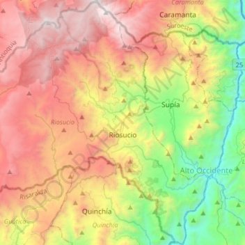
Name: Topografische Karte Riosucio, Höhe, Relief.
Ort: Riosucio, Alto Occidente, Caldas, Kolumbien (5.33586 -75.86740 5.56355 -75.60966)
Durchschnittliche Höhe: 1.899 m
Minimale Höhe: 631 m
Maximale Höhe: 3.250 m
Andere topografische Karten
Klicken Sie auf eine Karte, um ihre Topografie, ihre Höhe und ihr Relief anzuzeigen.
Riosucio
Riosucio liegt im Nordwesten von Caldas auf einer Höhe von 1783 Metern an der Ostflanke der westlichen Kordillere der kolumbianischen Anden. Die Jahresdurchschnittstemperatur beträgt 19–21 °C. Riosucio liegt 91 km von Manizales entfernt. An die Gemeinde grenzen im Norden Jardín und Támesis in Antioquia,…
Durchschnittliche Höhe: 1.743 m