Geolokalisieren

Topografische Karte São Jorge

Interaktive Karte

Klicken Sie auf die Karte, um die Höhe anzuzeigen.

Über diese Karte

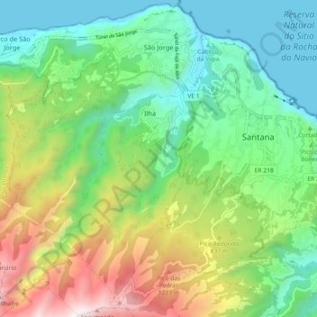
Name: Topografische Karte São Jorge, Höhe, Relief.

Ort: São Jorge, Santana, Madeira, 9230-142, Portugal (32.76174 -16.96055 32.83761 -16.89639)

Durchschnittliche Höhe: 581 m

Minimale Höhe: -1 m

Maximale Höhe: 1.767 m

Fifty kilometres from the regional capital, the parish is located 240 metres above sea level, limited in the north by the Atlantic Ocean and south by the mountains of the interior range (the heightest altitudes in the parish include Pico Canário 1,592 metres (5,223 ft) and Pico dos Assumadouros 1,184 metres (3,885 ft). To the west is the civil parish of Arco de São Jorge and east are the parishes of Ilha and Santana. About half of the parish is covered by the rich Laurissilva forest defined as Natural Heritage by UNESCO.

Wikipedia (CC-BY-SA 3.0)

Andere topografische Karten

Klicken Sie auf eine Karte, um ihre Topografie, ihre Höhe und ihr Relief anzuzeigen.

São Roque do Faial

Portugal > Santana

São Roque do Faial, Santana, Madeira, Portugal

Durchschnittliche Höhe: 632 m

Queimadas

Portugal > Santana

Queimadas, Santana, Madeira, 9230-108, Portugal

Durchschnittliche Höhe: 841 m

Praia de S. Jorge

Portugal > Santana > Calhau São Jorge

Praia de S. Jorge, Calhau, Calhau São Jorge, Santana, 9230-111, Portugal

Durchschnittliche Höhe: 121 m

Ilha

Portugal > Santana

Ilha, Santana, Madeira, Portugal

Durchschnittliche Höhe: 744 m